| Luha / Lug | |
|---|---|
 | |
| Location | |
| Country | |
| Physical characteristics | |
| Source | |
| • location | village Kolpytiv, Lokachi Raion |
| Mouth | Bug |
• coordinates | 50°52′02″N 24°08′44″E / 50.86722°N 24.14556°E |
| Length | 93 km (58 mi) |
| Basin size | 1,348 km2 (520 sq mi) |
| Basin features | |
| Progression | Bug→ Narew→ Vistula→ Baltic Sea |
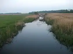
The Luha (Ukrainian: Луга, Polish: Ług) is a river in Ukraine and a right tributary of the Bug. Its source is located near the village of Kolpytiv in the Horokhiv Upland. In its upper reaches, the Luha runs mainly in a western, northwestern direction, and later northwards. In its lower stream, it runs mainly in a northwestern direction and enters the Western Bug on northwestern outskirts of the city of Ustyluh.
Biggest tributaries: Luha-Svynoryika, Svynoryika, Rylovytsia (right side); Strypa (left side)
Character of the river is plain as it flows through swampy floodplains.
Major settlements along the river: Volodymyr, Ustyluh
In 2000, local hydrological reserve "Luha" was created along the river.[1]
References
External links
- Luha at the OpenStreetMap
This article is issued from Wikipedia. The text is licensed under Creative Commons - Attribution - Sharealike. Additional terms may apply for the media files.