Lupara | |
|---|---|
| Comune di Lupara | |
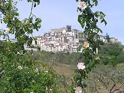 Panorama of Lupara | |
 Coat of arms | |
Location of Lupara | |
 Lupara Location of Lupara in Italy 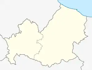 Lupara Lupara (Molise) | |
| Coordinates: 41°46′N 14°44′E / 41.767°N 14.733°E | |
| Country | Italy |
| Region | Molise |
| Province | Campobasso (CB) |
| Government | |
| • Mayor | Pasqualino Morinelli |
| Area | |
| • Total | 25.6 km2 (9.9 sq mi) |
| Elevation | 505 m (1,657 ft) |
| Population | |
| • Total | 484 |
| • Density | 19/km2 (49/sq mi) |
| Demonym | Luparesi |
| Time zone | UTC+1 (CET) |
| • Summer (DST) | UTC+2 (CEST) |
| Postal code | 86030 |
| Dialing code | 0874 |
| Website | Official website |
Lupara is a comune (municipality) in the Province of Campobasso in the Italian region Molise, located about 25 kilometres (16 mi) north of Campobasso.
Lupara borders the following municipalities: Casacalenda, Castelbottaccio, Civitacampomarano, Guardialfiera, Morrone del Sannio.
References
- ↑ "Superficie di Comuni Province e Regioni italiane al 9 ottobre 2011". Italian National Institute of Statistics. Retrieved 16 March 2019.
- ↑ All demographics and other statistics: Italian statistical institute Istat.
- ↑ "Popolazione Residente al 1° Gennaio 2018". Italian National Institute of Statistics. Retrieved 16 March 2019.
This article is issued from Wikipedia. The text is licensed under Creative Commons - Attribution - Sharealike. Additional terms may apply for the media files.