Mường Ảng district
Huyện Mường Ảng | |
|---|---|
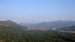 View of the mountains on way from Điện Biên Phủ to Sơn La | |
| Country | |
| Region | Northwest |
| Province | Dien Bien |
| Capital | Mường Ảng |
| Area | |
| • Total | 171.1 sq mi (443.2 km2) |
| Population (2006) | |
| • Total | 37,077 |
| • Density | 220/sq mi (84/km2) |
| Time zone | UTC+07:00 (Indochina Time) |
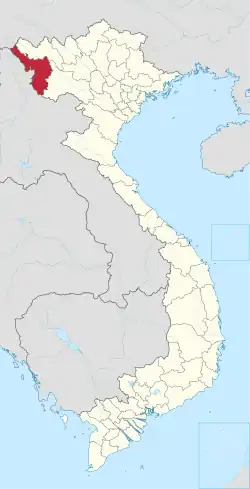
Mường Ảng is a district (huyện) of Điện Biên province in the Northwest region of Vietnam.
As of 2006, the district had a population 37,077.[1] The district covers an area of 443.2 km2. The district capital lies at Mường Ảng town.[1]
Mường Ảng is subdivided to a township and 9 rural communes, including Mường Ảng township and the communes of Ẳng Cang, Ẳng Nưa, Ẳng Tở, Búng Lao, Mường Đăng, Mường Lạn, Nặm Lịch, Ngối Cáy and Xuân Lao.
References
- 1 2 "Districts of Vietnam". Statoids. Retrieved March 13, 2009.
Capital: Điện Biên Phủ | ||
| Điện Biên Phủ |
|  |
| Mường Lay | ||
| Điện Biên |
| |
| Điện Biên Đông | ||
| Mường Ảng |
| |
| Mường Chà |
| |
| Mường Nhé | ||
| Nậm Pồ | ||
| Tủa Chùa | ||
| Tuần Giáo |
| |
| Điện Biên province |  | |
|---|---|---|
| Hòa Bình province | ||
| Lai Châu province | ||
| Lào Cai province | ||
| Sơn La province | ||
| Yên Bái province | ||
※ denotes provincial seat. | ||
This article is issued from Wikipedia. The text is licensed under Creative Commons - Attribution - Sharealike. Additional terms may apply for the media files.