| Maisinger Bach | |
|---|---|
 | |
| Location | |
| Country | Germany |
| State | Bavaria |
| Physical characteristics | |
| Mouth | |
• location | Lake Starnberg |
• coordinates | 47°59′51″N 11°21′00″E / 47.9976°N 11.3501°E |
| Length | 42.3 km (26.3 mi) [1] |
| Basin features | |
| Progression | Würm→ Amper→ Isar→ Danube→ Black Sea |
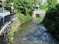
The Maisinger Bach is a river in Bavaria, Germany. It flows into Lake Starnberg, which is drained by the Würm, in Starnberg. Its climate type is temperate oceanic climate, and its length is 42 km.[2]
See also
References
- ↑ Complete table of the Bavarian Waterbody Register by the Bavarian State Office for the Environment (xls, 10.3 MB)
- ↑ "Maisinger Bach".
This article is issued from Wikipedia. The text is licensed under Creative Commons - Attribution - Sharealike. Additional terms may apply for the media files.