Malva | |
|---|---|
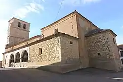 Church of San Miguel | |
 Flag  Seal | |
 Malva Location in Spain | |
| Coordinates: 41°39′15″N 5°29′10″W / 41.65417°N 5.48611°W | |
| Country | |
| Autonomous community | |
| Province | |
| Comarca | Alfoz de Toro |
| Judicial District | Zamora |
| Mancomunidad | Norte-Duero |
| Government | |
| • Mayor | Manuel Masero Pastor (PSOE) |
| Area | |
| • Total | 27.33 km2 (10.55 sq mi) |
| Elevation | 713 m (2,339 ft) |
| Population (2018)[1] | |
| • Total | 131 |
| • Density | 4.8/km2 (12/sq mi) |
| Demonym | Malvarisco / Malvarisca |
| Time zone | UTC+1 (CET) |
| • Summer (DST) | UTC+2 (CEST) |
| Postal code | 49832 |
| Area code | (+34) 980 |
| Website | Official website |
Malva is a municipality located in the province of Zamora, Castile and León, Spain.[2] According to the 2012 census (INE), the municipality has a population of 167 inhabitants.[3]
Geography
Located in south of the natural reserve of Lagunas de Villafáfila, Malva is 17 km far from Toro, 33 from Zamora and 83 from Valladolid.[4]
See also
References
- ↑ Municipal Register of Spain 2018. National Statistics Institute.
- ↑ (in Spanish) Malva on Zamora Province website
- ↑ (in Spanish) Source: INE 2012
- ↑ (in Spanish) Map and infos about Malva (Pueblos de España)
External links
- (in Spanish) Malva official website
This article is issued from Wikipedia. The text is licensed under Creative Commons - Attribution - Sharealike. Additional terms may apply for the media files.