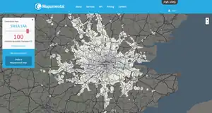
 Interactive isochrone map on Mapumental.com | |
| Owner | mySociety |
|---|---|
| Created by | Chris Lightfoot, Francis Irving, Matthew Somerville, Duncan Parkes, Steve Day, Dave Arter |
| URL | mapumental |
| Launched | 2006 |
| Written in | Perl |
Mapumental was a web-based application for displaying journeys in terms of how long they take,[1] rather than by distance, a technique also known as isochrone or geospatial mapping.[2][3] It was developed by British organisation mySociety but was withdrawn in 2020.[4]
Users input one or more postcodes and Mapumental displays a map overlaid with coloured bands, each of which represent a set increment of time. Initial work on the project was done by Chris Lightfoot, using open data from Railplanner, Transport Direct and the Transport for London Journey Planner.[5]
It was built with support from Channel 4iP,[6] the former public service arm of British TV broadcaster Channel 4.[7] The software the Mapumental runs on is licensed under the GNU Affero General Public License.[8]
Mapumental can be combined with other data sets, for example, property prices[9] and ‘scenicness’ data (see ScenicorNot, below).[10][11][12][13][14] It is now provided as a commercial service by mySociety to clients such as the Fire Protection Association.[15]
References
- ↑ "These tools let you map journey times in the world's major cities". 12 November 2015. Retrieved 6 August 2016.
- ↑ "Mapumental: Travel time maps". Retrieved 6 August 2016.
- ↑ New Directions in Political Science - Responding to the Challenges of an Interdependent World. Palgrave Macmillan. 2016-10-16. ISBN 9780230228481. Retrieved 6 August 2016.
- ↑ "Mapumental". Archived from the original on 28 April 2020. Retrieved 19 October 2021.
- ↑ "Travel time maps: methods / mySociety". 4 March 2006.
- ↑ Logan, Alasdair (23 April 2010). "Exploiting U.K. Government Linked Data" (PDF). University of Aberdeen. p. 21. Retrieved 19 August 2018.
- ↑ Jackson, Lizzie (23 August 2010). Harnessing collaborative innovation for the evolution of public service media. RIPE Conference. CiteSeerX 10.1.1.663.9440.
- ↑ Lightfoot, Chris (4 March 2006). "Travel time maps: methods". Retrieved 19 August 2018.
Our software is available under the terms of the GNU Affero GPL.
- ↑ "Mapumental".
- ↑ Fawkes, Piers (June 1, 2009). "Live Where It's Most Scenic With Mapumental". psfk. Retrieved March 22, 2012.
- ↑ "House-hunting goes hi-tech". The Independent. November 25, 2009. Retrieved March 22, 2012.
- ↑ Gadney, Max (Winter 2010). "Understand, visualise, survive". Eye. No. 78. Retrieved March 22, 2012.
- ↑ "MySociety launches Mapumental". Recruiter. Sep 14, 2011. Retrieved March 22, 2012.
- ↑ "Say hello to Mapumental". My Society. June 2009.
- ↑ "Fire, fire! Mapumental and fire engine journey times / mySociety". 22 April 2013.