| McLeod Glacier | |
|---|---|
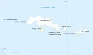 Location of McLeod Glacier in the South Orkney Islands | |
| Location | South Orkney Islands |
| Coordinates | 60°44′S 45°38′W / 60.733°S 45.633°W |
| Length | 1 nmi (2 km; 1 mi) |
| Terminus | Clowes Bay |
McLeod Glacier is a glacier 1 nautical mile (2 km) long, flowing in a southeasterly direction into Clowes Bay on the south side of Signy Island, in the South Orkney Islands off Antarctica. It was named by the UK Antarctic Place-Names Committee in 1954 for Michael McLeod, following a survey by the Falkland Islands Dependencies Survey in 1947. On 12 December 1821, the cutter Beaufoy under McLeod sailed to a position at least 60 nautical miles (110 km) west of the South Orkney Islands, where a chart annotation indicates that land was sighted, possibly Coronation Island.[1][2]
See also
References
- ↑ "McLeod Glacier". Geographic Names Information System. United States Geological Survey, United States Department of the Interior. Retrieved 9 September 2013.
- ↑ Alberts, Fred G., ed. (June 1995). Geographic Names of the Antarctic (PDF) (second ed.). United States Board on Geographic Names. p. 479. Retrieved 5 April 2012.
![]() This article incorporates public domain material from "McLeod Glacier". Geographic Names Information System. United States Geological Survey.
This article incorporates public domain material from "McLeod Glacier". Geographic Names Information System. United States Geological Survey.
60°44′S 45°38′W / 60.733°S 45.633°W