Mehan, Oklahoma | |
|---|---|
 Mehan  Mehan | |
| Coordinates: 36°2′41″N 96°56′33″W / 36.04472°N 96.94250°W | |
| Country | United States |
| State | Oklahoma |
| County | Payne |
| Area | |
| • Total | 0.14 sq mi (0.36 km2) |
| • Land | 0.14 sq mi (0.36 km2) |
| • Water | 0.00 sq mi (0.00 km2) |
| Elevation | 830 ft (250 m) |
| Population (2020) | |
| • Total | 34 |
| • Density | 242.86/sq mi (94.03/km2) |
| Time zone | UTC-6 (Central (CST)) |
| • Summer (DST) | UTC-5 (CDT) |
| ZIP Code | 74074 (Stillwater) |
| Area code(s) | 405/572 |
| FIPS code | 40-47550 |
| GNIS feature ID | 2812866[2] |
Mehan is an unincorporated community and census-designated place (CDP) in Payne County, Oklahoma, United States. It was first listed as a CDP prior to the 2020 census.[2]
The CDP is in central Payne County, on the northeast side of the valley of Stillwater Creek, a southeast-flowing tributary of the Cimarron River. Mehan is 11 miles (18 km) southeast of Stillwater, the Payne county seat, and 10 miles (16 km) northeast of Perkins.
Demographics
| Census | Pop. | Note | %± |
|---|---|---|---|
| 2020 | 34 | — | |
| U.S. Decennial Census[3] | |||
References
- ↑ "ArcGIS REST Services Directory". United States Census Bureau. Retrieved September 20, 2022.
- 1 2 3 U.S. Geological Survey Geographic Names Information System: Mehan, Oklahoma
- ↑ "Census of Population and Housing". Census.gov. Retrieved June 4, 2016.
Municipalities and communities of Payne County, Oklahoma, United States | ||
|---|---|---|
| Cities | 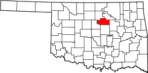 Map of Oklahoma highlighting Payne County | |
| Towns | ||
| CDPs | ||
| Other communities | ||
| Ghost town | ||
| Footnotes | ‡This populated place also has portions in an adjacent county or counties | |
This article is issued from Wikipedia. The text is licensed under Creative Commons - Attribution - Sharealike. Additional terms may apply for the media files.