Merig | |
|---|---|
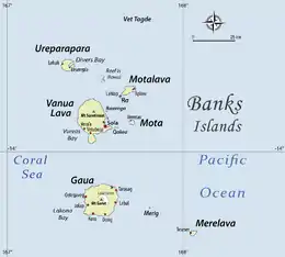 Location of Merig in Banks Islands | |
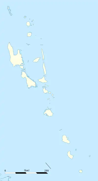 Merig Location in Vanuatu | |
| Coordinates: 14°19′S 167°48′E / 14.317°S 167.800°E | |
| Country | |
| Province | Torba Province |
| Area | |
| • Total | 0.5 km2 (0.2 sq mi) |
| [1] | |
| Population (2009) | |
| • Total | 12 |
| • Density | 24/km2 (62/sq mi) |
| Time zone | UTC+11 (VUT) |
Merig is a small island located 20 kilometres (12 miles) east of Gaua, in the Banks Islands of northern Vanuatu.
The island is about 800 metres (2,600 feet) wide, and has a circumference of 2.2 kilometres (1 mile).
Name
The name Merig [ŋ͡mʷeriɣ] comes from the Mota language. It comes from a Proto-Torres-Banks form *mʷera riɣi "the small boy" via haplology to *mʷeriɣi. It contrasts with Merelava, from *mʷera lava "the big boy". The native term in Mwerlap is N̄wërig [ŋʷɞˈriɣ], from the same etymon.
History
The first recorded sighting of Merig Island by Europeans was by the Spanish expedition of Pedro Fernández de Quirós on 25 April 1606.[2] It was then named Île Sainte Claire.[3]
Population
Merig is only inhabited by one household, consisting of 12 individuals.[4]
They speak Mwerlap,[5] the language of the neighbouring island Merelava.
References
- ↑ "Vanuatu". Haos Blong Volkeno. Archived from the original on 8 August 2018. Retrieved 8 August 2018.
- ↑ Sharp, Andrew The discovery of the Pacific Islands Oxford, 1960, p.65.
- ↑ Sidney Herbert Ray (29 May 2014). A Comparative Study of the Melanesian Island Languages. Cambridge University Press. pp. 427–. ISBN 978-1-107-68202-3.
- ↑
"2009 National Census of Population and Housing: Summary Release" (PDF). Vanuatu National Statistics Office. 2009. Retrieved October 11, 2010.
{{cite journal}}: Cite journal requires|journal=(help) - ↑ Languages of the Banks & Torres Islands.
External links
- "Merig". Global Volcanism Program. Smithsonian Institution. Retrieved 2021-06-28.