Mesa, Colorado | |
|---|---|
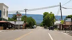 Looking towards the Grand Mesa in Mesa on Highway 65 | |
 Mesa  Mesa | |
| Coordinates: 39°09′59″N 108°08′20″W / 39.16639°N 108.13889°W | |
| Country | |
| State | |
| County | Mesa[1] |
| Elevation | 5,643 ft (1,720 m) |
| Time zone | UTC-7 (MST) |
| • Summer (DST) | UTC-6 (MDT) |
| ZIP code[2] | 81643 |
| Area code | 970 |
| GNIS feature ID | 174463[1] |
Mesa is an unincorporated community in Mesa County, Colorado, United States.
Description
The Mesa Post Office has the ZIP Code 81643.[2] Mesa is located on the north side of the Grand Mesa on state highway 65. in a geographic area known as Plateau Valley, and is under the Plateau Valley 50 District Public Schools.
See also
References
- 1 2 3 U.S. Geological Survey Geographic Names Information System: Mesa, Colorado
- 1 2 "ZIP Code Lookup". United States Postal Service. January 2, 2007. Archived from the original (JavaScript/HTML) on January 1, 2008. Retrieved January 2, 2007.
External links
![]() Media related to Mesa, Colorado at Wikimedia Commons
Media related to Mesa, Colorado at Wikimedia Commons
Municipalities and communities of Mesa County, Colorado, United States | ||
|---|---|---|
| Cities | 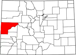 Map of Colorado highlighting Mesa County | |
| Towns | ||
| CDPs | ||
| Unincorporated communities | ||
| Ghost towns | ||
This article is issued from Wikipedia. The text is licensed under Creative Commons - Attribution - Sharealike. Additional terms may apply for the media files.