Mikolajice | |
|---|---|
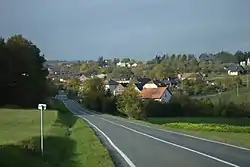 General view | |
 Flag  Coat of arms | |
 Mikolajice Location in the Czech Republic | |
| Coordinates: 49°52′38″N 17°47′36″E / 49.87722°N 17.79333°E | |
| Country | |
| Region | Moravian-Silesian |
| District | Opava |
| First mentioned | 1389 |
| Area | |
| • Total | 7.40 km2 (2.86 sq mi) |
| Elevation | 354 m (1,161 ft) |
| Population (2023-01-01)[1] | |
| • Total | 299 |
| • Density | 40/km2 (100/sq mi) |
| Time zone | UTC+1 (CET) |
| • Summer (DST) | UTC+2 (CEST) |
| Postal code | 747 84 |
| Website | www |
Mikolajice is a municipality and village in Opava District in the Moravian-Silesian Region of the Czech Republic. It has about 300 inhabitants.
History
The first written mention of Mikolajice is from 1389.[2]
Gallery
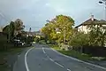 Main road
 Houses
References
- ↑ "Population of Municipalities – 1 January 2023". Czech Statistical Office. 2023-05-23.
- ↑ "Historie" (in Czech). Obec Mikolajice. Retrieved 2022-03-28.
External links
Wikimedia Commons has media related to Mikolajice.
This article is issued from Wikipedia. The text is licensed under Creative Commons - Attribution - Sharealike. Additional terms may apply for the media files.