Mixtlán | |
|---|---|
Municipality and town | |
| Nickname(s): In its native náhuatl, Mixtlán mean lugar de nubes or Place of Clouds.[1] | |
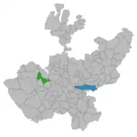 Location of the municipality in Jalisco | |
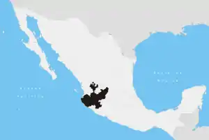
 Mixtlán Location in Mexico | |
| Coordinates: 20°22′N 104°15′W / 20.367°N 104.250°W | |
| Country | |
| State | Jalisco |
| Area | |
| • Total | 631 km2 (244 sq mi) |
| • Town | 1.91 km2 (0.74 sq mi) |
| Population (2020 census)[2] | |
| • Total | 3,638 |
| • Density | 5.8/km2 (15/sq mi) |
| • Town | 1,710 |
| • Town density | 900/km2 (2,300/sq mi) |
| Time zone | UTC-6 (Central Standard Time) |
| • Summer (DST) | UTC-5 (Central Daylight Time) |
Mixtlán is a town and municipality, in Jalisco in central-western Mexico. The municipality covers an area of 631 square kilometres (244 sq mi). It first became a Municipality on October 20, 1938. In its native Náhuatl, Mixtlán means place of clouds.
As of 2005, the municipality had a total population of 3279.[3]
References
- ↑ "Mixtlán | Gobierno del Estado de Jalisco".
- ↑ Citypopulation.de
- ↑ "Mixtlán". Enciclopedia de los Municipios de México. Instituto Nacional para el Federalismo y el Desarrollo Municipal. Archived from the original on March 24, 2007. Retrieved April 16, 2009.
http://iglesiacasadelrey.com/index.php?option=com_content&view=article&id=51&Itemid=67
This article is issued from Wikipedia. The text is licensed under Creative Commons - Attribution - Sharealike. Additional terms may apply for the media files.