Moho | |
|---|---|
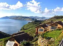 Suwasi (Suasi) island and Lake Titicaca, Moho Province | |
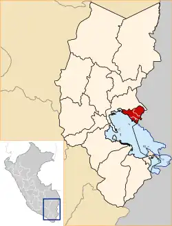 Location of Moho in the Puno Region | |
| Country | Peru |
| Region | Puno |
| Capital | Moho |
| Government | |
| • Mayor | Randolfo Mamani Aracayo |
| Area | |
| • Total | 1,005.25 km2 (388.13 sq mi) |
| Elevation | 3,841 m (12,602 ft) |
| Population | |
| • Total | 28,149 |
| • Density | 28/km2 (73/sq mi) |
| UBIGEO | 2109 |
Moho Province is a province of the Puno Region in Peru.[1]
Political division
The province measures 1,005.25 square kilometres (388.13 sq mi) and is divided into four districts:
| District | Mayor | Capital | Ubigeo |
|---|---|---|---|
| Conima | Alejandro Apaza Quispe | Conima | 210902 |
| Huayrapata | Juan De Dios Cauna Chiara | Huayrapata | 210903 |
| Moho | Randolfo Mamani Aracayo | Moho | 210901 |
| Tilali | Zenon Alan Cañazaca Blanco | Tilali | 210904 |
Ethnic groups
The people in the province are mainly indigenous citizens of Aymara descent. Aymara is the language which the majority of the population (85.42%) learnt to speak in childhood, 13.70% of the residents started speaking using the Spanish language and 0.55% using Quechua (2007 Peru Census).[2]
See also
References
- ↑ (in Spanish) Instituto Nacional de Estadística e Informática. Banco de Información Digital Archived 2008-04-23 at the Wayback Machine, Retrieved January 2, 2008
- ↑ inei.gob.pe Archived 2013-01-27 at the Wayback Machine INEI, Peru, Censos Nacionales 2007
| |
|---|---|
15°21′39″S 69°29′59″W / 15.360764°S 69.499844°W
This article is issued from Wikipedia. The text is licensed under Creative Commons - Attribution - Sharealike. Additional terms may apply for the media files.