Monarch, Wyoming | |
|---|---|
 Monarch, Wyoming | |
| Coordinates: 44°54′11″N 107°02′06″W / 44.90306°N 107.03500°W | |
| Country | United States |
| State | Wyoming |
| County | Sheridan |
| Elevation | 3,655 ft (1,114 m) |
| Time zone | UTC-7 (Mountain (MST)) |
| • Summer (DST) | UTC-6 (MDT) |
| Area code | 307 |
| GNIS feature ID | 1597415[1] |
Monarch is an unincorporated community in Sheridan County, Wyoming, United States. Monarch is located along Interstate 90, 8.3 miles (13.4 km) north-northwest of Sheridan. It was founded in 1903 as one of many coal company towns in the area. It was all but abandoned in 1953.[2] Monarch is 3,650 feet (1,113 m) above sea level. Monarch area code (307).
References
- 1 2 "Monarch". Geographic Names Information System. United States Geological Survey, United States Department of the Interior.
- ↑ Dobson, Geoffrey B. "Sheridan Area Coal Camp Photos". Wyoming Tales and Trails. Retrieved November 24, 2015.
Municipalities and communities of Sheridan County, Wyoming, United States | ||
|---|---|---|
| City | 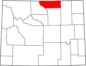 | |
| Towns | ||
| CDPs | ||
| Other communities | ||
This article is issued from Wikipedia. The text is licensed under Creative Commons - Attribution - Sharealike. Additional terms may apply for the media files.