Montgirod | |
|---|---|
Part of Aime-la-Plagne | |
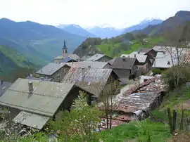 A view across the rooftops to the church | |
Location of Montgirod | |
 Montgirod  Montgirod | |
| Coordinates: 45°32′00″N 6°35′00″E / 45.5333°N 6.5833°E | |
| Country | France |
| Region | Auvergne-Rhône-Alpes |
| Department | Savoie |
| Arrondissement | Albertville |
| Canton | Bourg-Saint-Maurice |
| Commune | Aime-la-Plagne |
| Area 1 | 13.62 km2 (5.26 sq mi) |
| Population (2021)[1] | 483 |
| • Density | 35/km2 (92/sq mi) |
| Time zone | UTC+01:00 (CET) |
| • Summer (DST) | UTC+02:00 (CEST) |
| Postal code | 73210 |
| Elevation | 556–2,255 m (1,824–7,398 ft) |
| Website | www.mairie-montgirod-centron.fr |
| 1 French Land Register data, which excludes lakes, ponds, glaciers > 1 km2 (0.386 sq mi or 247 acres) and river estuaries. | |
Montgirod (French pronunciation: [mɔ̃ʒiʁo]; Arpitan: Montsou) is a former commune in the Savoie department in the Auvergne-Rhône-Alpes region in south-eastern France. On 1 January 2016, it was merged into the new commune of Aime-la-Plagne.[2] In August 1994, its town hall square was renamed the "Place du Colonel Peter Ortiz", after U.S. Marine Corps officer Peter J. Ortiz.
Population
| Year | Pop. | ±% p.a. |
|---|---|---|
| 2006 | 426 | — |
| 2011 | 450 | +1.10% |
| 2021 | 483 | +0.71% |
| Source: INSEE[3][1] | ||
See also
References
- 1 2 "Populations légales 2021" [Legal populations 2021] (PDF) (in French). INSEE. December 2023.
- ↑ Arrêté préfectoral 17 November 2015
- ↑ Populations légales 2011, INSEE
External links
Wikimedia Commons has media related to Montgirod.
This article is issued from Wikipedia. The text is licensed under Creative Commons - Attribution - Sharealike. Additional terms may apply for the media files.