Moodys, Oklahoma | |
|---|---|
 Moodys, Oklahoma  Moodys, Oklahoma | |
| Coordinates: 36°01′56″N 94°57′21″W / 36.03222°N 94.95583°W | |
| Country | United States |
| State | Oklahoma |
| County | Cherokee |
| Area | |
| • Total | 17.48 sq mi (45.28 km2) |
| • Land | 17.48 sq mi (45.27 km2) |
| • Water | 0.00 sq mi (0.01 km2) |
| Elevation | 932 ft (284 m) |
| Population (2020) | |
| • Total | 854 |
| • Density | 48.86/sq mi (18.87/km2) |
| Time zone | UTC-6 (Central (CST)) |
| • Summer (DST) | UTC-5 (CDT) |
| ZIP code | 74444 |
| Area code(s) | 918 & 539 |
| GNIS feature ID | 2805342[2] |
Moodys is an unincorporated community in Cherokee County, Oklahoma, United States.[2] The community is 8 miles (13 km) north of Tahlequah. Moodys has a post office with ZIP code 74444, which opened on March 21, 1896.[3][4]
Demographics
| Census | Pop. | Note | %± |
|---|---|---|---|
| 2020 | 854 | — | |
| U.S. Decennial Census[5] | |||
References
- ↑ "ArcGIS REST Services Directory". United States Census Bureau. Retrieved September 20, 2022.
- 1 2 3 U.S. Geological Survey Geographic Names Information System: Moodys, Oklahoma
- ↑ United States Postal Service. "USPS - Look Up a ZIP Code". Retrieved January 23, 2016.
- ↑ "Postmaster Finder - Post Offices by ZIP Code". United States Postal Service. Retrieved January 23, 2016.
- ↑ "Census of Population and Housing". Census.gov. Retrieved June 4, 2016.
Municipalities and communities of Cherokee County, Oklahoma, United States | ||
|---|---|---|
| City | 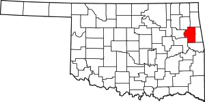 Cherokee County map | |
| Towns | ||
| CDPs | ||
| Other community | ||
| Indian reservation | ||
| Footnotes | ‡This populated place also has portions in an adjacent county or counties | |
This article is issued from Wikipedia. The text is licensed under Creative Commons - Attribution - Sharealike. Additional terms may apply for the media files.