| Mount Balbi | |
|---|---|
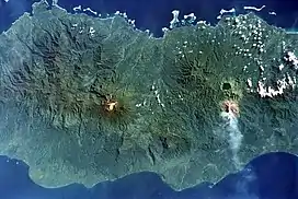 Mount Balbi is the light-colored area at the center of the image. | |
| Highest point | |
| Elevation | 2,715 m (8,907 ft) |
| Prominence | 2,715 m (8,907 ft) |
| Isolation | 752.26 km (467.43 mi) |
| Listing | Ultra |
| Coordinates | 05°54′51″S 154°58′57″E / 5.91417°S 154.98250°E |
| Geography | |
 Mount Balbi Papua New Guinea | |
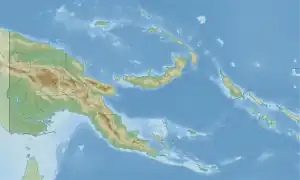
| Location | Bougainville, Papua New Guinea |
| Parent range | Emperor Range |
| Geology | |
| Age of rock | Appr. 10 to 12 000 years ago |
| Mountain type | Stratovolcano |
| Last eruption | Not in historic time |
Mount Balbi is a Holocene stratovolcano located in the northern portion of the island of Bougainville, Papua New Guinea. A gentle prominence at 05°54′09″S 154°59′28″E / 5.90250°S 154.99111°E is the highest point of the island. There are five volcanic craters east of the summit, one of which contains a crater lake. The summit is composed of coalesced cones and lava domes which host a large solfatara field.[1] There are numerous fumaroles near the craters, though Balbi has not erupted in historic time.
See also
References
- ↑ "Global Volcanism Program | Balbi". Smithsonian Institution | Global Volcanism Program. Retrieved 2022-03-15.
- "Balbi". Global Volcanism Program. Smithsonian Institution. Retrieved 2020-10-07.
- Bagana Volcano and Balbi Volcano, Bougainville Island
This article is issued from Wikipedia. The text is licensed under Creative Commons - Attribution - Sharealike. Additional terms may apply for the media files.