Mtskheta-Mtianeti
მცხეთა-მთიანეთი | |
|---|---|
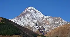
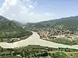
From the top to bottom-right: Kazbegi National Park, Gergeti Trinity Church, Lake Tina in Juta Valley, Pshav-Khevsureti National Park, Mtskheta | |
.svg.png.webp) Overlapping borders of de jure Mtskheta-Mtianeti region and de facto South Ossetia[nt 1] | |
| Country | |
| Seat | Mtskheta |
| Subdivisions | 5 Municipalities[1] |
| Government | |
| • Governor | Davit Nozadze[2] |
| Area | |
| • Total | 5,606 km2 (2,164 sq mi) |
| Population (2021)[4] | |
| • Total | 93,389 |
| • Density | 17/km2 (43/sq mi) |
| ISO 3166 code | GE-MM |
| HDI (2019) | 0.755[5] high · 10th |
| Website | www |


Mtskheta-Mtianeti (Georgian: მცხეთა-მთიანეთი, literally "Mtskheta-Mountain Area") is a region (Mkhare) in eastern Georgia comprising the town of Mtskheta, which serves as a regional capital, together with its district and the adjoining mountainous areas. The western part of the region, namely the entire Akhalgori Municipality, is controlled by breakaway South Ossetia[nt 1] since the 2008 Russo-Georgian War.
Administrative divisions
The Mtskheta-Mtianeti region officially comprises five municipalities,[1] yet only four are effectively under Georgian authority:
| Municipality | Pop. (2021) | Town/Village | Pop. (2021) |
|---|---|---|---|
| Akhalgori[nt 2] | 3,665 [6] | Akhalgori | 1,033 (2015 [7]) |
| Dusheti | 26,328 | Dusheti | 6,864 |
| Kazbegi | 3,781 | Stepantsminda | 1,443 |
| Mtskheta | 53,006 | Mtskheta | 7,606 |
| Tianeti | 10,274 | Tianeti | 3,084 |
| Source: Geostat[4] | |||
See also
Notes
- 1 2 South Ossetia's status is disputed. It considers itself to be an independent state, but this is recognised by only a few other countries. The Georgian government and most of the world's other states consider South Ossetia de jure a part of Georgia's territory.
- ↑ With the formation of mkhare (regions) in 1995, Akhalgori was officially classified as part of the Mtskheta-Mtianeti region. Since the 2008 Russo-Georgian War the Georgian central government lost effective controle over Akhalgori.
References
- 1 2 "Regions and municipalities of Georgia" (in Georgian). Georgian Government. Retrieved 2022-02-04.
- ↑ "7 ახალი გუბერნატორიდან ყველა კაცია". NETGAZETI.ge.
- ↑ Nominal area 6,785 km², de facto controlled by Georgia 5,606 km².
- 1 2 "Population and Demography - Population by cities and boroughs as of 1 January". National Statistics Office of Georgia (Geostat). Retrieved 2021-11-26.
- ↑ "Sub-national HDI - Area Database - Global Data Lab". hdi.globaldatalab.org. Retrieved 2018-09-13.
- ↑ "Statistical compilation for 2020" (in Russian). Department of State Statistics of the Republic of South Ossetia. 24 March 2021. Retrieved 2021-11-26.
- ↑ "Results of the general population census of RSO 2015" (in Russian). Department of State Statistics of the Republic of South Ossetia. 20 December 2016. Retrieved 2021-11-26.
External links
Wikimedia Commons has media related to Mtskheta-Mtianeti
- (in Georgian) The Regional Administration of Mtskheta-Mtianeti website
| Autonomous republics | .svg.png.webp) | |
|---|---|---|
| Regions | ||
| City with special status |
| |
| Other | ||
42°17′N 44°45′E / 42.283°N 44.750°E
This article is issued from Wikipedia. The text is licensed under Creative Commons - Attribution - Sharealike. Additional terms may apply for the media files.