Munmudaewang-myeon | |
|---|---|
myeon | |
| Korean transcription(s) | |
| • Hangul | 문무대왕면 |
| • Hanja | 文武大王面 |
| • Revised Romanization | Munmudaewang-myeon |
| • McCune–Reischauer | Munmudaewang-myŏn |
 | |
| Country | South Korea |
| Region | Gyeongju |
| Administrative divisions | 21 administrative ri (15 legal ri), 90 ban |
| Government | |
| • Type | Gyeongju City |
| Area | |
| • Total | 120.06 km2 (46.36 sq mi) |
| Population (2006)[1] | |
| • Total | 4,558 |
| • Density | 38/km2 (100/sq mi) |
| Dialect | Gyeongsang dialect |
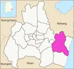
Munmudaewang-myeon is a myeon or a township in the administrative subdivisions of the Gyeongju City, North Gyeongsang province, South Korea. It is bordered by Gampo-eup and Sea of Japan (East Sea) on the east, Yangnam-myeon on the south, Bulguk-dong, Bodeok-dong and Oedong-eup on the west and Ocheon-eup and Janggi-myeon of the Pohang city on the north. Its 120.06 square kilometers are home to about 4,558 people.[1] This population is served by one joint elementary-middle school.[2]
Administrative divisions
- Gugil-ri (구길리)
- Gwoni-ri (권이리)
- Dusan-ri (두산리)
- Beopgok-ri (범곡리)
- Bonggil-ri (봉길리)
- Songjeon-ri (송전리)
- Andong-ri (안동리)
- Eoil-ri (어일리)
- Waeup-ri (와읍리)
- Yongdang-ri (용당리)
- Yongdong-ri (용동리)
- Ipcheon-ri (입천리)
- Janghang-ri (장항리)
- Jukjeon-ri (죽전리)
- Hoam-ri (호암리)
See also
References
- 1 2 "양북면 Yangbuk-myeon 陽北面" (in Korean). Doosan Encyclopedia. Retrieved 2009-08-17.
- ↑ 교육기관 [Educational institution] (in Korean). Gyeongju City. Retrieved 2009-08-17.
External links
- (in Korean) The official site of the Yangbuk-myeon office
4 eup, 8 myeon, 11 dong | ||
| Eup (town) |  | |
| Myeon (township) | ||
| Dong (neighborhood) | ||
| See also | ||
Website: www.gyeongju.go.kr | ||
This article is issued from Wikipedia. The text is licensed under Creative Commons - Attribution - Sharealike. Additional terms may apply for the media files.