Nangar Khel | |
|---|---|
 Nangar Khel Location in Afghanistan | |
| Coordinates: 32°26′23″N 68°22′8″E / 32.43972°N 68.36889°E | |
| Country | |
| Province | Paktika Province |
| Elevation | 6,990 ft (2,130 m) |
| Time zone | UTC+4:30 |
Nangar Khel (also: Nangarkhēl, Nangar Kheyl) is a village in the Paktika Province, southeastern Afghanistan, located in the mountains at the altitude of 2,130 metres (6,990 ft). Its coordinates are 32°26′23″N 68°22′8″E / 32.43972°N 68.36889°E.
See also
References
| Districts | 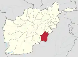 | |
|---|---|---|
| Populated places | ||
| Other | ||
This article is issued from Wikipedia. The text is licensed under Creative Commons - Attribution - Sharealike. Additional terms may apply for the media files.