Nekvasovy | |
|---|---|
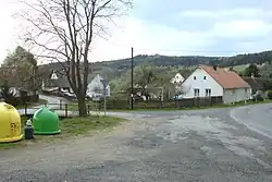 Centre of Nekvasovy | |
 Flag  Coat of arms | |
 Nekvasovy Location in the Czech Republic | |
| Coordinates: 49°26′5″N 13°37′33″E / 49.43472°N 13.62583°E | |
| Country | |
| Region | Plzeň |
| District | Plzeň-South |
| First mentioned | 1558 |
| Area | |
| • Total | 6.04 km2 (2.33 sq mi) |
| Elevation | 479 m (1,572 ft) |
| Population (2023-01-01)[1] | |
| • Total | 187 |
| • Density | 31/km2 (80/sq mi) |
| Time zone | UTC+1 (CET) |
| • Summer (DST) | UTC+2 (CEST) |
| Postal code | 335 47 |
| Website | www |
Nekvasovy is a municipality and village in Plzeň-South District in the Plzeň Region of the Czech Republic. It has about 200 inhabitants.
Nekvasovy lies approximately 40 kilometres (25 mi) south-east of Plzeň and 93 km (58 mi) south-west of Prague.
Gallery
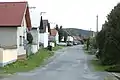 A street
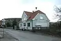 Municipal office
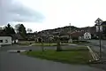 Park in the centre
References
Wikimedia Commons has media related to Nekvasovy.
This article is issued from Wikipedia. The text is licensed under Creative Commons - Attribution - Sharealike. Additional terms may apply for the media files.