| Newton River | |
|---|---|
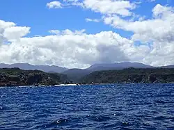 West Cape & Newton River Mouth | |
 | |
| Location | |
| Country | New Zealand |
| Physical characteristics | |
| Source | |
| • location | Lake Fraser |
| • elevation | 31 m (102 ft) |
| Mouth | |
• location | West Cape |
• elevation | 0m |
| Length | 9 km (5.6 mi) |
The Newton River is a river in Fiordland, New Zealand. It drains Lake Fraser south-westward into the Tasman Sea just south of West Cape.[1]
Newton River is an official name, gazetted on 4 February 1960, after being in use by local fishermen for some time. It is about 9 km (5.6 mi) long.[2]
The river flows over the Newton River pluton of Carbonferous biotite, granodiorite and granite, which has been glaciated and also forms a rock arch to the south of the river mouth, where a marine terrace has been uplifted within the last half a million years.[3]
The beech forest in the valley includes black beech (tawairauriki), kāmahi, and silver beech (tawhai).[4]
See also
References
- ↑ "Newton River, Southland". NZ Topo Map. Retrieved 23 December 2022.
- ↑ "Newton River". gazetteer.linz.govt.nz. Retrieved 23 December 2022.
- ↑ "Geology of the Fiordland Area - GNS Science". yumpu.com. 2010. p. 10. Retrieved 23 December 2022.
- ↑ P. WARDLE, A. F. MARK and G. T. S. BAYLIS (28 August 1973). "Vegetation and Landscape of the West Cape District" (PDF). Coastal restoration trust.
"Place name detail: Newton River". New Zealand Gazetteer. New Zealand Geographic Board. Retrieved 12 July 2009.
45°54′S 166°28′E / 45.900°S 166.467°E