Niederwölz | |
|---|---|
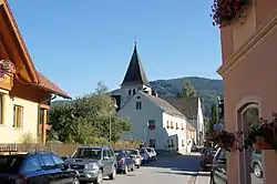 Street with parish church | |
 Coat of arms | |
 Niederwölz Location within Austria | |
| Coordinates: 47°09′00″N 14°22′00″E / 47.15000°N 14.36667°E | |
| Country | Austria |
| State | Styria |
| District | Murau |
| Government | |
| • Mayor | Walter Koller (ÖVP) |
| Area | |
| • Total | 10.25 km2 (3.96 sq mi) |
| Elevation | 748 m (2,454 ft) |
| Population (2018-01-01)[2] | |
| • Total | 596 |
| • Density | 58/km2 (150/sq mi) |
| Time zone | UTC+1 (CET) |
| • Summer (DST) | UTC+2 (CEST) |
| Postal code | 8811, 8831 |
| Area code | 03582 |
| Vehicle registration | MU |
| Website | www.niederwoelz. steiermark.at |
Niederwölz is a municipality in the district of Murau in the Austrian state of Styria.
Geography
Niederwölz lies in the upper valley of the Mur.
References
- ↑ "Dauersiedlungsraum der Gemeinden Politischen Bezirke und Bundesländer - Gebietsstand 1.1.2018". Statistics Austria. Retrieved 10 March 2019.
- ↑ "Einwohnerzahl 1.1.2018 nach Gemeinden mit Status, Gebietsstand 1.1.2018". Statistics Austria. Retrieved 9 March 2019.
This article is issued from Wikipedia. The text is licensed under Creative Commons - Attribution - Sharealike. Additional terms may apply for the media files.