Nijkerkerveen | |
|---|---|
Village | |
 | |
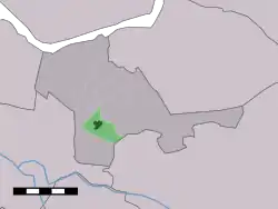 The village centre (dark green) and the statistical district (light green) of Nijkerkerveen in the municipality of Nijkerk. | |
 Nijkerkerveen Location in the province of Gelderland in the Netherlands  Nijkerkerveen Nijkerkerveen (Netherlands) | |
| Coordinates: 52°11′42″N 5°28′0″E / 52.19500°N 5.46667°E | |
| Country | Netherlands |
| Province | Gelderland |
| Municipality | Nijkerk |
| Area | |
| • Total | 3.78 km2 (1.46 sq mi) |
| Elevation | 3 m (10 ft) |
| Population (2021)[1] | |
| • Total | 3,530 |
| • Density | 930/km2 (2,400/sq mi) |
| Time zone | UTC+1 (CET) |
| • Summer (DST) | UTC+2 (CEST) |
| Postal code | 3864[1] |
| Dialing code | 033 |
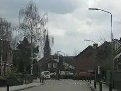
Nijkerkerveen is a village in the Dutch province of Gelderland. It is a part of the municipality of Nijkerk, and lies about 6 km east of Amersfoort.
It was first mentioned in 1807 as Nieuwkerker Vheen, and means "bog near Nijkerk".[3] In 1840, it was home to 1,197 people. In 1908, the first church was built.[4]
References
- 1 2 3 "Kerncijfers wijken en buurten 2021". Central Bureau of Statistics. Retrieved 23 March 2022.
- ↑ "Postcodetool for 3864DE". Actueel Hoogtebestand Nederland (in Dutch). Het Waterschapshuis. Retrieved 23 March 2022.
- ↑ "Nijkerkerveen - (geografische naam)". Etymologiebank (in Dutch). Retrieved 23 March 2022.
- ↑ "Nijkerkerveen". Plaatsengids (in Dutch). Retrieved 23 March 2022.
External links
Wikimedia Commons has media related to Nijkerkerveen.
This article is issued from Wikipedia. The text is licensed under Creative Commons - Attribution - Sharealike. Additional terms may apply for the media files.