Offord and Buckden | |
|---|---|
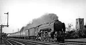 ECML express passing Offord & Buckden station and St Peter's Church in 1955 | |
| General information | |
| Location | Offord Cluny, Huntingdonshire England |
| Grid reference | TL217671 |
| Other information | |
| Status | Disused |
| History | |
| Original company | Great Northern Railway |
| Pre-grouping | Great Northern Railway |
| Post-grouping | London and North Eastern Railway |
| Key dates | |
| September 1851 | Opened as Offord |
| 1 August 1876 | Renamed Offord and Buckden |
| 2 February 1959 | Closed for passengers |
| 26 April 1965 | closed for freight |
Offord and Buckden railway station was built by the Great Northern Railway to serve the twin villages of Offord Cluny and Offord D'Arcy in Cambridgeshire, England.
History
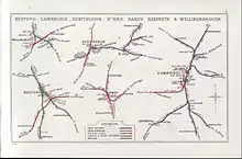
A 1914 Railway Clearing House map showing (upper centre) railways in the vicinity of Offord & Buckden
The Great Northern Railway main line from London to Peterborough had opened in 1850 including stations at St. Neots and Huntingdon.[1] A station between these, named Offord, was opened just over a year later, in September 1851.[2][3] It was located 56 miles (90 km) from London King's Cross.[4]
On 1 August 1876 the station was renamed Offord and Buckden.[3]
The station closed for passengers on 2 February 1959.[3]
Route
| Preceding station | Historical railways | Following station | ||
|---|---|---|---|---|
| St. Neots Line and station open |
Great Northern Railway East Coast Main Line |
Huntingdon Line and station open | ||
Notes
- ↑ Butt 1995, pp. 125, 204.
- ↑ Conolly 1976, p. 11, section C2.
- 1 2 3 Butt 1995, p. 176.
- ↑ Yonge 2006, map 15C.
References
- Butt, R. V. J. (October 1995). The Directory of Railway Stations: details every public and private passenger station, halt, platform and stopping place, past and present (1st ed.). Sparkford: Patrick Stephens Ltd. ISBN 978-1-85260-508-7. OCLC 60251199. OL 11956311M.
- Conolly, W. Philip (January 1976). British Railways Pre-Grouping Atlas and Gazetteer (5th ed.). Shepperton: Ian Allan. ISBN 0-7110-0320-3. EX/0176.
- Yonge, John (September 2006) [1994]. Jacobs, Gerald (ed.). 2: Eastern. Railway Track Diagrams (3rd ed.). Bradford on Avon: Trackmaps. ISBN 0-9549866-2-8.
52°17′21″N 0°12′57″W / 52.2892°N 0.2157°W
This article is issued from Wikipedia. The text is licensed under Creative Commons - Attribution - Sharealike. Additional terms may apply for the media files.