Orlovice | |
|---|---|
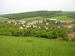 General view | |
 Flag  Coat of arms | |
 Orlovice Location in the Czech Republic | |
| Coordinates: 49°14′21″N 17°5′37″E / 49.23917°N 17.09361°E | |
| Country | |
| Region | South Moravian |
| District | Vyškov |
| First mentioned | 1328 |
| Area | |
| • Total | 14.47 km2 (5.59 sq mi) |
| Elevation | 320 m (1,050 ft) |
| Population (2023-01-01)[1] | |
| • Total | 299 |
| • Density | 21/km2 (54/sq mi) |
| Time zone | UTC+1 (CET) |
| • Summer (DST) | UTC+2 (CEST) |
| Postal code | 682 01 |
| Website | www |
Orlovice is a municipality and village in Vyškov District in the South Moravian Region of the Czech Republic. It has about 300 inhabitants.
Orlovice lies approximately 8 kilometres (5 mi) south-east of Vyškov, 35 km (22 mi) east of Brno, and 215 km (134 mi) south-east of Prague.
References
Wikimedia Commons has media related to Orlovice.
This article is issued from Wikipedia. The text is licensed under Creative Commons - Attribution - Sharealike. Additional terms may apply for the media files.