Oxford Township | |
|---|---|
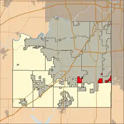 Location in Johnson County | |
| Coordinates: 38°50′06″N 94°45′10″W / 38.83500000°N 94.75277778°W | |
| Country | United States |
| State | Kansas |
| County | Johnson |
| Area | |
| • Total | 43.10 sq mi (111.6 km2) |
| • Land | 42.98 sq mi (111.3 km2) |
| • Water | 0.12 sq mi (0.3 km2) |
| Elevation | 728 ft (222 m) |
| Population (2,048) | |
| • Total | 2,020 |
| • Density | 24.9/sq mi (9.6/km2) |
| Time zone | Central |
| ZIP codes | 66061, 66202 |
| Area code | 913 |
| GNIS feature ID | 479234 |
Oxford Township is one of seven townships in Johnson County, Kansas, USA. As of the 2010 census, its population was 2,020.
Adjacent Townships
- Olathe Township West
Cemeteries
- Aubry Cemetery
Emergency Services
Police
- Johnson County Sheriff
- Overland Park Police
- Olathe Police
Fire
- Johnson County Rural Fire Department
- Overland Park Fire
- Olathe Fire
Medical (EMS)
- Olathe Medical Center
- Shawnee Mission Medical Center
- Overland Park Regional Medical Center
- Miami County Medical Center
Transportation
Major highways
School districts
- Blue Valley School District
External links
- "Township of Oxford". Geographic Names Information System. United States Geological Survey. Retrieved January 4, 2014.
Municipalities and communities of Johnson County, Kansas, United States | ||
|---|---|---|
| Cities | 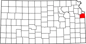 Map of Kansas highlighting Johnson County | |
| Unincorporated communities | ||
| Townships | ||
| Footnotes | ‡This community also has portions in an adjacent county or counties. | |
This article is issued from Wikipedia. The text is licensed under Creative Commons - Attribution - Sharealike. Additional terms may apply for the media files.