| Pen y Garn | |
|---|---|
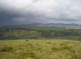 The Nant Rhuddnant gorge looking north to Cefn Croes from the summit of Pen y Garn. In the background is Y Garn (left), Pen Pumlumon Fawr and Pen Pumlumon Arwystli (right) | |
| Highest point | |
| Elevation | 611 m (2,005 ft) |
| Prominence | 194 m (636 ft) |
| Parent peak | Plynlimon |
| Listing | Marilyn, Hewitt, Nuttall |
| Coordinates | 52°22′43″N 3°46′00″W / 52.3785°N 3.7666°W |
| Naming | |
| Language of name | Welsh |
| Geography | |
| Location | Ceredigion, Wales |
| Parent range | Cambrian Mountains |
| OS grid | SN798771 |
| Topo map | OS Landranger 147 or 135 |
Pen y Garn is a mountain in the Cambrian Mountains, Mid Wales standing at 611 metres above sea level.
Pen y Garn tops a 500–600 m high plateau, which includes the controversial Cefn Croes wind farm. The summit has a very large shelter cairn hollowed out from the remains of an ancient burial cairn and a trig point. The wind turbines are very near the summit. To the north some 10 km, the whole Plynlimon range can be seen, including the summits of Y Garn, Pen Pumlumon Fawr, Pen Pumlumon Llygad-bychan and Pen Pumlumon Arwystli. 21 km to the west is the town of Aberystwyth; Drygarn Fawr lies 20 km to the SSE .[1]
References
This article is issued from Wikipedia. The text is licensed under Creative Commons - Attribution - Sharealike. Additional terms may apply for the media files.