Phong Tân | |
|---|---|
Commune and village | |
 Phong Tân Location in Vietnam | |
| Coordinates: 9°18′06″N 105°26′25″E / 9.3017°N 105.4403°E | |
| Country | |
| Province | Bạc Liêu Province |
| District | Giá Rai District |
| Area | |
| • Total | 20.87 sq mi (54.06 km2) |
| Population (2009-04-01)[1] | |
| • Total | 13,697 |
| • Density | 656/sq mi (253.4/km2) |
| Time zone | UTC+7 (UTC+7) |
Phong Tân is a commune (xã) and village located in Giá Rai District, Bạc Liêu Province, in south-western Vietnam.[2]
References
- ↑ "Phong Tân (Rural Commune, Vietnam) - Population Statistics, Charts, Map and Location". www.citypopulation.de. Retrieved 2023-10-25.
- ↑ Ministry of Public Information in Vietnam
Capital: Bạc Liêu | ||
| Bạc Liêu | 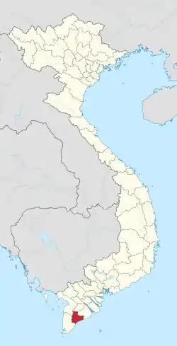 | |
| Giá Rai | ||
| Đông Hải District | ||
| Hòa Bình District | ||
| Hồng Dân District | ||
| Phước Long District | ||
| Vĩnh Lợi District | ||
This article is issued from Wikipedia. The text is licensed under Creative Commons - Attribution - Sharealike. Additional terms may apply for the media files.