Plattenburg | |
|---|---|
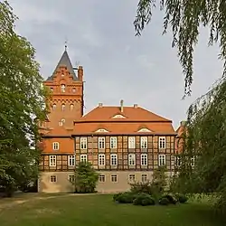 Plattenburg Castle | |
 Coat of arms | |
Location of Plattenburg within Prignitz district 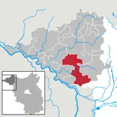 | |
 Plattenburg  Plattenburg | |
| Coordinates: 52°58′00″N 12°01′59″E / 52.96667°N 12.03306°E | |
| Country | Germany |
| State | Brandenburg |
| District | Prignitz |
| Government | |
| • Mayor (2020–28) | Anja Kramer[1] |
| Area | |
| • Total | 200.76 km2 (77.51 sq mi) |
| Elevation | 32 m (105 ft) |
| Population (2021-12-31)[2] | |
| • Total | 3,290 |
| • Density | 16/km2 (42/sq mi) |
| Time zone | UTC+01:00 (CET) |
| • Summer (DST) | UTC+02:00 (CEST) |
| Postal codes | 19336 |
| Dialling codes | 038796 |
| Vehicle registration | PR |
| Website | www.plattenburg.de |
Plattenburg is a municipality in the Prignitz district, in Brandenburg, Germany. It is named after the water castle of Plattenburg which is located in the district.
Demography
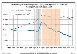 Development of population since 1875 within the current Boundaries (Blue Line: Population; Dotted Line: Comparison to Population development in Brandenburg state; Grey Background: Time of Nazi Germany; Red Background: Time of communist East Germany)
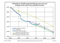 Recent Population Development and Projections (Population Development before Census 2011 (blue line); Recent Population Development according to the Census in Germany in 2011 (blue bordered line); Official projections for 2005-2030 (yellow line); for 2017-2030 (scarlet line); for 2020-2030 (green line)
|
|
|
References
- ↑ Landkreis Prignitz Wahl der Bürgermeisterin / des Bürgermeisters, accessed 2 July 2021.
- ↑ "Bevölkerungsentwicklung und Flächen der kreisfreien Städte, Landkreise und Gemeinden im Land Brandenburg 2021" (PDF). Amt für Statistik Berlin-Brandenburg (in German). June 2022.
- ↑ Detailed data sources are to be found in the Wikimedia Commons.Population Projection Brandenburg at Wikimedia Commons
Towns and municipalities in Prignitz | ||
|---|---|---|
Coat of Arms of Prignitz district | ||
This article is issued from Wikipedia. The text is licensed under Creative Commons - Attribution - Sharealike. Additional terms may apply for the media files.