Pomabamba | |
|---|---|
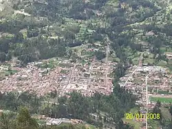 Pomabamba | |
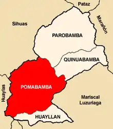 Location of Pomabamba in the Pomabamba province | |
| Country | |
| Region | Ancash |
| Province | Pomabamba |
| Founded | February 21, 1861 |
| Capital | Pumapampa |
| Government | |
| • Mayor | Julian Watson Cirilo Diestra (2007) |
| Area | |
| • Total | 347.92 km2 (134.33 sq mi) |
| Elevation | 2,948 m (9,672 ft) |
| Population | |
| • Total | 14,780 |
| • Density | 42/km2 (110/sq mi) |
| Time zone | UTC-5 (PET) |
| UBIGEO | 021601 |
| Website | munipomabamba.gob.pe |
Pomabamba (Quechua Pumaq pampa, pumaq cougar, pampa large plain,[1] "cougar plain") is the largest of 4 districts in the Pomabamba Province of the Ancash Region in Peru.[2]
Ethnic groups
The people in the district are mainly indigenous citizens of Quechua descent. Quechua is the language which the majority of the population (76.16%) learnt to speak in childhood, 23.62% of the residents started speaking using the Spanish language (2007 Peru Census).[3]
Climate
| Climate data for Pomabamba (elevation 2,985 m (9,793 ft), 1991–2020 normals) | |||||||||||||
|---|---|---|---|---|---|---|---|---|---|---|---|---|---|
| Month | Jan | Feb | Mar | Apr | May | Jun | Jul | Aug | Sep | Oct | Nov | Dec | Year |
| Mean daily maximum °C (°F) | 21.6 (70.9) |
21.3 (70.3) |
20.9 (69.6) |
21.2 (70.2) |
21.9 (71.4) |
21.9 (71.4) |
22.1 (71.8) |
22.5 (72.5) |
22.5 (72.5) |
22.3 (72.1) |
22.7 (72.9) |
21.7 (71.1) |
21.9 (71.4) |
| Mean daily minimum °C (°F) | 7.3 (45.1) |
7.6 (45.7) |
7.5 (45.5) |
7.4 (45.3) |
6.1 (43.0) |
4.4 (39.9) |
3.9 (39.0) |
4.5 (40.1) |
5.9 (42.6) |
6.8 (44.2) |
7.0 (44.6) |
7.4 (45.3) |
6.3 (43.4) |
| Average precipitation mm (inches) | 140.9 (5.55) |
133.2 (5.24) |
148.2 (5.83) |
102.7 (4.04) |
40.0 (1.57) |
12.0 (0.47) |
6.8 (0.27) |
10.5 (0.41) |
36.6 (1.44) |
99.7 (3.93) |
91.6 (3.61) |
145.2 (5.72) |
967.4 (38.08) |
| Source: National Meteorology and Hydrology Service of Peru[4] | |||||||||||||
See also
See also
External links
- (in Spanish) Official website of the Pomabamba Province
References
- ↑ Teofilo Laime Ajacopa (2007). Diccionario Bilingüe: Iskay simipi yuyayk’anch: Quechua – Castellano / Castellano – Quechua (PDF). La Paz, Bolivia: futatraw.ourproject.org.
- ↑ INEI Archived 2007-06-01 at the Wayback Machine
- ↑ inei.gob.pe Archived 2013-01-27 at the Wayback Machine INEI, Peru, Censos Nacionales 2007, Frequencias: Preguntas de Población: Idioma o lengua con el que apredió hablar (in Spanish)
- ↑ "Normales Climaticás Estándares y Medias 1991-2020". National Meteorology and Hydrology Service of Peru. Archived from the original on 21 August 2023. Retrieved 6 November 2023.
| Aija | |
|---|---|
| Antonio Raymondi | |
| Asunción | |
| Bolognesi | |
| Carhuaz | |
| Carlos Fermín Fitzcarrald | |
| Casma | |
| Corongo | |
| Huaraz | |
| Huari | |
| Huarmey | |
| Huaylas | |
| Mariscal Luzuriaga | |
| Ocros | |
| Pallasca | |
| Pomabamba | |
| Recuay | |
| Santa | |
| Sihuas | |
| Yungay | |
8°49′59″S 77°28′01″W / 8.83306°S 77.46694°W
This article is issued from Wikipedia. The text is licensed under Creative Commons - Attribution - Sharealike. Additional terms may apply for the media files.