 Punta Pioppeto Lighthouse | |
| Location | Procida Campania Italy |
|---|---|
| Coordinates | 40°46′13″N 14°01′01″E / 40.770407°N 14.016876°E |
| Tower | |
| Constructed | 1849 |
| Construction | masonry building |
| Automated | yes |
| Height | 3 metres (9.8 ft) |
| Shape | post atop a 1-storey equipment building |
| Markings | white building |
| Power source | mains electricity |
| Operator | Marina Militare[1][2] |
| Light | |
| Focal height | 21 metres (69 ft) |
| Lens | Type TD |
| Intensity | LABI 100 W |
| Range | 11 nautical miles (20 km; 13 mi) |
| Characteristic | Fl (3) W 10s. |
| Italy no. | 2358 E.F. |
Punta Pioppeto Lighthouse (Italian: Faro di Punta Pioppeto) is an active lighthouse located on the northernmost promontory of Procida, Campania on the Tyrrhenian Sea.
Description
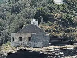
The lighthouse was built in 1849 and consisted of 1-storey octagonal base keeper's house, now in a state of completely disuse and devastation, since the last keeper left and the lighthouse was automated. The active lighthouse is a post atop a 1-storey equipment white building, 10 feet (3.0 m) high, located in a higher position. The light is positioned at 21 metres (69 ft) above sea level and emits three white flashes in a 10 seconds period, visible up to a distance of 11 nautical miles (20 km; 13 mi). The lighthouse is completely automated and operated by the Marina Militare with the identification code number 2358 E.F.[2][3]
See also
References
- ↑ Rowlett, Russ. "Lighthouses of Italy: Campania and Lazio". The Lighthouse Directory. University of North Carolina at Chapel Hill. Retrieved March 12, 2018.
- 1 2 "Punta Pioppeto". Marina Militare. Retrieved March 12, 2018.
- ↑ "Procida devastato il faro". Corriere del Mezzogiorno. Retrieved March 12, 2018.
External links