Rafael Rangel Municipality
Municipio Rafael Rangel | |
|---|---|
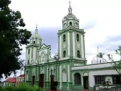 The Saint-Jean-Baptiste church in Betijoque | |
 Flag  Seal | |
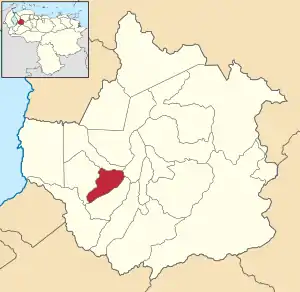 Location in Trujillo | |
.svg.png.webp) Rafael Rangel Municipality Location in Venezuela | |
| Coordinates: 9°22′54″N 70°44′03″W / 9.38167°N 70.73417°W | |
| Country | |
| State | Trujillo |
| Municipal seat | Betijoque |
| Government | |
| • Mayor | José Leonardo Chirino (PSUV) |
| Area | |
| • Total | 120 km2 (50 sq mi) |
| Elevation | 122 m (400 ft) |
| Population (2011) | |
| • Total | 22,153[1] |
| Time zone | UTC−4 (VET) |
Rafael Rangel is one of the 20 municipalities of the state of Trujillo, Venezuela. The municipality occupies an area of 120 km2 with a population of 22,153 inhabitants according to the 2011 census.
Parishes
The municipality consists of the following four parishes:
- Betijoque
- José Gregorio Hernánde
- La Pueblita
- Los Cedros
References
- ↑ "Resultados por entidad federal y municipios del Estado Trujillo" (PDF). Censo nacional de población y vivienda 2011. INE. December 2014. Retrieved 25 November 2021.
This article is issued from Wikipedia. The text is licensed under Creative Commons - Attribution - Sharealike. Additional terms may apply for the media files.