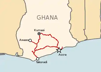
Railway network of Ghana
The railway stations in Ghana serve a rail network concentrated in the south of the country.
Maps
- UNHCR Atlas Map Ghana - shows Topography.
- UN Map Ghana - shows Provinces
- GhanaNet Map Archived 2018-10-19 at the Wayback Machine
Towns served by rail
Existing
The following towns or villages currently have or had rail service in Ghana; 1,067 mm (3 ft 6 in) gauge unless otherwise noted :

Accra station platforms and canopy.
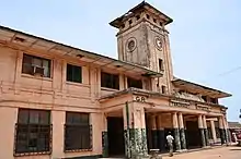
Takoradi Railway Station.
East
- Accra - (E) - port, capital city: Accra Central Station
- Baatsona
- Asoprochona - suburban terminus
- Koforidua (E)
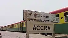 Accra sign post
 - Pokoasi - (E/C) - junction
- Shai Hills - (E)
- Tema - (E) - port in east - proposed suburban terminus 2008 [1]
- Nsawam - (E)
- Koforidua (E)
- Nkawkaw - (E)
- Ejisu - (E)
- Nsuta
- Juaso (C)
- Konongo, Ghana (E)
- Boankra (E) - inland port
- Kumasi (E/W) - junction [2]
West
Railway in the western part of Ghana is formalised by the Western Railway Line and has stations passing through the following towns.
- Sekondi - (W) - older port and workshops
- Tarkwa - (W) - junction
- Takoradi - (W) - newer port
- Huni Valley - (W/C) - junction on west line for cross country line to east line; concrete sleeper plant
- Dunkwa - (W) - Junction for Awaso
- Obuasi - (W) 85.5 km
- Bekwai - (W)
- Kumasi - (W/E) junction 0.0 km
Centre
- Huni Valley - (W/C) - junction
- Twifu Praso
- Foso (C)
- Achissi - (C) - junction
- Akoroso (C)
- Pokoasi
- Kotoku - (E/C) - junction
Eastern Border
Proposed
This list includes regauged stations.
Far Northern Line (West)
 Takoradi - port - break of gauge 1,067 mm (3 ft 6 in)/1,435 mm (4 ft 8+1⁄2 in)
- Manso
- Tarkwa - junction for northwest
- Huni Valley
- Dunkwa
- Nyinahim
- Sunyani (regional capital Brong-Ahafo)
- Techiman - junction
- Bole
- Salwa
- Wa (regional capital Upper West Region)
- Hamile - northwest terminus - 1,435 mm (4 ft 8+1⁄2 in)
- Border -
- Border
- Burkina Faso
- Ouagadougou - junction
Far Northern Line (East)
1,435 mm (4 ft 8+1⁄2 in) [7] under construction 2020
- Tema - Port
- Mpakadan
- Kpeve
- Hohoe
- Jasikan
- Bimbila
- Yendi
- Tamale (regional capital Northern Region)
- Walewale
- Bolgatanga (regional capital Upper East Region)
- Navrongo
- Paga
- Akosombo
- Ho (regional capital Volta Region)
- Hohoe
- Paga (0 km)
- - - Border (Ghana-Burkina Faso) [8]
- Po
- Dakola
- Zabre
- Tenkodogo
- Manga
- Bagre
- Ouagadougou - junction - national capital (166 km) (1000 km from Tema)
- (Suburban)
- Dansoman
- La, Ghana
- Teshie, Ghana
ECOWAS Coastal Line
- (proposed 2010) [9]
 Aflao - near border in east with Togo, and capital Lomé.
- Togo-Ghana border
- Tema
- Accra - national capital
- Winneba
- Cape Coast (regional capital Central Region, Ghana)
- Takoradi (regional capital Western Region, Ghana)
- Omanpe
-
 Ghana-Côte d'Ivoire border
Approved
- Kumasi - (W/E) junction (2010)
- Bolgatanga
- Navrongo
- Paga - near Burkina Faso[10]
(far eastern line)
- Ejisu
- Mampong
- Nkoranza
- Tamale - junction
- Bolgatanga
- Paga - near Burkina Faso
- Tamale
- Yendi
- Shieni - iron ore
- Buipe - just north of lake
- Lake Volta
Suburban
(Suburban line)
- Accra
- Sakumono
- Asoprochona
- Tema - large port to east of Accra [11]
- Kasoa
- Winneba - west of Accra on coast.
- Madina
Lake Volta branch to east:
- Achimota (E) - junction
- Tema (E) - major port [12]
- Sugbaniate (E)
- Shai Hills (E)
- Akosombo (E) - inland lake port
Rehab 2008
- Bosusi
- Kibi - bauxite deposit
Other
- Kumasi, Boankra inland port, Kumasi-Paga through Buipe, to connect the Volta lake, Achimota-Tema port, Tamale-Yendi to connect Shieni (227m) iron deposit, Bosusi-Kibi to connect the bauxite deposit at Kibi and branch lines linking the towns where other mineral deposits have been identified.
- Takoradi through Manso, Tarkwa, Huni Valley, Dunkwa Awaso, Nyinahin, Sunyani, Techiman, Bole, Sawla, Wa through to Hamile in the Upper West Region of Ghana.[14]
- Ghana Railway Development Authority has invited bids to convert the 950 km rail network from 1,067 mm (3 ft 6 in) narrow gauge to standard gauge, permitting 25 tonne axleloads and increasing speeds from 56 to 160 km/h. In the longer term, feasibility studies will look at introducing a suburban rail service from Accra to Kasoa, Winneba and Madina, as well as extending the railway to the north and connecting with the proposed Ecowas rail line across West Africa.
Closed
Timeline
2020
2019
201?
- Accra
- Avenor, Ghana
2010
- Ghana proposes part of the ECOWAS Coastal Railway linking Aflao-Tema-Accra, Winneba, Cape Coast, Takoradi and Omape.[9]
- The Government of Ghana and the China National Machinery Import and Export Corporation (CMC) has signed a US $6.050 billion contract agreement for the construction of a railway infrastructure from Nsawam near Accra via Kumasi to Paga on the Burkina Faso border, and a branch from same at Tamale to Yendi.
2009
Standards
- Couplings : AAR
- Brakes : Air
See also
References
- ↑ A Tema Port (E) proposed Archived 2009-10-01 at the Wayback Machine. ghanacedi.gov.gh.
- ↑ Eastern Line
- ↑ "Railpage".
- ↑ Cement siding opened.
- ↑ Railway Gazette International June 2008 p354 (Map)
- ↑ Canada supports Ghana-Burkina Faso railway project. modernghana.com.
- ↑ "Contractors asked to submit bids for Ghana-Burkina Faso rail".
- ↑ Ghana plans
- 1 2 Ghana proposed ECOWAS coastal line. railwaysafrica.com. December 2010.
- ↑ Ghana to Receive Loan from China Exim Bank. railway-technology.com. 28 September 2010.
- ↑ 가나 아크라~테마 노선 강화 사업 구상
- ↑ Ghana Invests in Railway Upgrade. railway-technology.com. 21 October 2010.
- ↑ The Baatsonaa & Nungua bridge completed. modernghana.com.
- ↑ The transformation of Ghana's rail. thestatesmanonline.com. 15 August 2007.
- ↑ Kumasi-Obuasi
- ↑ Kumasi-Obuasi
- ↑ Accra-Kumasi
- ↑ BF-GH
- ↑ Manso - Dunkwa
- ↑ Western SG line
- ↑ http://www.railwaysafrica.com/blog/2011/02/28/new-lines-in-ghana/
- ↑ Railway Gazette International October 2009 p11
- ↑ Ghana Plans Major Rail Construction. railway-technology.com. 26 August 2009.
External links
This article is issued from Wikipedia. The text is licensed under Creative Commons - Attribution - Sharealike. Additional terms may apply for the media files.