| Relief Map of Mindanao | |
|---|---|
 | |
| Artist | Jose Rizal |
| Completion date | 1892[1] |
| Subject | Geography of Mindanao |
| Designation | National Cultural Treasure |
| Location | Dapitan Heritage Zone, Dapitan |
| 8°39′17″N 123°25′29″E / 8.65485°N 123.42475°E | |
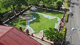
The Relief Map of Mindanao in Dapitan, Philippines, is a landscaping work by Jose Rizal. It is situated near the St. James the Greater Church.[2]
It is recognized by the National Historical Commission of the Philippines as a National Cultural Treasure[3]
References
- ↑ "Maps and Plans Made by Rizal". JoseRizal.ph. Jose Rizal University. Retrieved 5 November 2023.
- ↑ "Tourism". City of Dapitan Website. Retrieved 5 November 2023.
- ↑ Lapeña, Carmela (1 June 2011). "Dapitan in Mindanao named historical zone". GMA News. Retrieved 5 November 2023.
This article is issued from Wikipedia. The text is licensed under Creative Commons - Attribution - Sharealike. Additional terms may apply for the media files.