Rockenstuhl | |
|---|---|
 Coat of arms | |
Location of Rockenstuhl | |
 Rockenstuhl 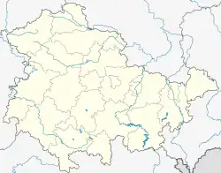 Rockenstuhl | |
| Coordinates: 50°40′N 09°56′E / 50.667°N 9.933°E | |
| Country | Germany |
| State | Thuringia |
| District | Wartburgkreis |
| Disbanded | 2008-12-31 |
| Area | |
| • Total | 30.39 km2 (11.73 sq mi) |
| Elevation | 385 m (1,263 ft) |
| Population (2006-12-31) | |
| • Total | 1,347 |
| • Density | 44/km2 (110/sq mi) |
| Time zone | UTC+01:00 (CET) |
| • Summer (DST) | UTC+02:00 (CEST) |
| Postal codes | 36419 |
| Dialling codes | 036967 |
| Vehicle registration | WAK |
Rockenstuhl is a former municipality in the Wartburgkreis district of Thuringia, Germany. It was created in March 1994 by the merger of the former municipalities Geismar, Ketten and Spahl.[1] Since 31 December 2008, it is part of the town Geisa.[2]
References
This article is issued from Wikipedia. The text is licensed under Creative Commons - Attribution - Sharealike. Additional terms may apply for the media files.