Roio del Sangro | |
|---|---|
| Comune di Roio del Sangro | |
 | |
Location of Roio del Sangro | |
 Roio del Sangro Location of Roio del Sangro in Italy 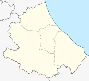 Roio del Sangro Roio del Sangro (Abruzzo) | |
| Coordinates: 41°55′N 14°22′E / 41.917°N 14.367°E | |
| Country | Italy |
| Region | Abruzzo |
| Province | Chieti (CH) |
| Area | |
| • Total | 11 km2 (4 sq mi) |
| Elevation | 840 m (2,760 ft) |
| Population (2004)[2] | |
| • Total | 138 |
| • Density | 13/km2 (32/sq mi) |
| Demonym | Roiesi |
| Time zone | UTC+1 (CET) |
| • Summer (DST) | UTC+2 (CEST) |
| Postal code | 66040 |
| Dialing code | 0872 |
| Patron saint | San Filippo Neri |
| Saint day | 12 July |
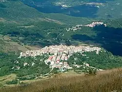
Roio del Sangro is a village and comune of the province of Chieti in the Abruzzo region of central Italy.
Notes and references
Wikimedia Commons has media related to Roio del Sangro.
- ↑ "Superficie di Comuni Province e Regioni italiane al 9 ottobre 2011". Italian National Institute of Statistics. Retrieved 16 March 2019.
- ↑ "Popolazione Residente al 1° Gennaio 2018". Italian National Institute of Statistics. Retrieved 16 March 2019.
This article is issued from Wikipedia. The text is licensed under Creative Commons - Attribution - Sharealike. Additional terms may apply for the media files.