| Rough Fire | |
|---|---|
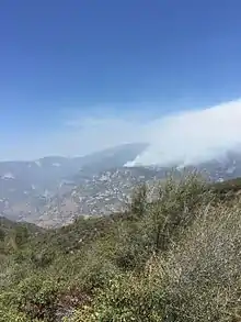 The Rough Fire on August 8. The area where this picture was taken was burned in the fire one week later. | |
| Location | Sierra National Forest, Fresno County, California |
| Coordinates | 36°52′26″N 118°54′18″W / 36.874°N 118.905°W |
| Statistics[1] | |
| Date(s) | July 31, 2015 – November 5, 2015 |
| Burned area | 151,623 acres (61,360 ha) |
| Cause | Lightning |
| Buildings destroyed | 4 |
| Non-fatal injuries | 10 |
The Rough Fire was a wildfire of the 2015 California season. It burned 151,623 acres (61,360 ha) of land, a season record, and was extinguished by 3,742 firefighters.[1]
Progression
The fire, caused by a lightning strike on July 31, approximately 5 miles (8.0 km) North of Hume Lake, burned mainly in the Sierra National Forest and Sequoia National Forest.[1]
On September 2, over 2,500 people were safely evacuated from Hume Lake Christian Camps and surrounding area. All camp events were cancelled and only security personnel remained.[2][3]
On September 5, the fire reached Kings Canyon National Park as it crossed the 85,800-acre (347 km2) mark.[4]
On September 7, a severely burned firefighter was airlifted to the Community Regional Medical Center in Fresno.[5]
On September 10, officials at Kings Canyon National Park began evacuating all visitors and employees from the Wilsonia and General Grant Grove areas. A mandatory evacuation order was issued for Dunlap, effective September 11.[6]
On September 11, Fresno health officials reported an unprecedented increase in hospital emergency department visits due to respiratory problems, and urged residents to avoid outdoor activities when the air is smoky.[7]
On September 15, as the fire slowed and with favorable weather conditions, evacuation orders and warnings in Dunlap and Squaw Valley were lifted.[8] By that time, 3,742 firefighters, 345 engines, 19 helicopters and 45 bulldozers had been deployed.[9]
As of November 5, the Rough Fire is 100% contained.
Area by ownership
As of October 6, 2015, the total burned area breaks down into:[1]
| Owner | Acres | Km2 |
|---|---|---|
| Sequoia National Forest | 82,573 | 334.2 |
| Sierra National Forest | 58,541 | 236.9 |
| Kings Canyon National Park | 9,413 | 38.1 |
| Private lands | 1,090 | 4.4 |
| State lands | 6 | 0.0 |
| Total | 151,623 | 613.6 |
References
- 1 2 3 4 "Rough Fire". InciWeb. Archived from the original on September 16, 2015. Retrieved October 3, 2015.
- ↑ "Forest fire continues to spread". Porterville Recorder. September 2015. Retrieved October 31, 2015.
- ↑ "Rough fire focus of community meeting in Dunlap". fresnobee. Retrieved October 31, 2015.
- ↑ "Rough fire reaches Kings Canyon National Park". The Fresno Bee. September 5, 2015. Retrieved September 6, 2015.
- ↑ "Rough Fire forces new evacuations, firefighter injured". KSBY. September 8, 2015. Retrieved September 10, 2015.
- ↑ Ginise, Megan; Appleton, Rory (September 10, 2015), "Rough fire forces evacuations in Dunlap, Grant Grove, Wilsonia", Fresno Bee, retrieved September 12, 2015
- ↑ Aliferis, Lisa (September 11, 2015). "In Fresno, 'Unprecedented Increase' in ER Visits Due to Rough Fire". KQED. San Francisco. Retrieved September 13, 2015.
- ↑ "Evacuation Orders and Warnings Lifted". InciWeb. Retrieved September 15, 2015.
- ↑ "Rough Fire Update AM September 15, 2015". InciWeb. Retrieved September 15, 2015.
| Pre-2000 |
|
|---|---|
| 2000 | |
| 2001 | |
| 2002 | |
| 2003 | |
| 2004 | |
| 2005 | |
| 2006 | |
| 2007 | |
| 2008 | |
| 2009 | |
| 2010 | |
| 2011 | |
| 2012 | |
| 2013 | |
| 2014 | |
| 2015 | |
| 2016 | |
| 2017 | |
| 2018 | |
| 2019 | |
| 2020 | |
| 2021 | |
| 2022 | |
| 2023 | |
| |

