Ruby Bay | |
|---|---|
Rural settlement | |
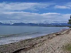 The view from Ruby Bay beach across Tasman Bay to Nelson and the Barnicoat Range. | |
| Coordinates: 41°14′10″S 173°04′59″E / 41.236°S 173.083°E | |
| Country | New Zealand |
| Territorial authority | Tasman |
| Ward | Moutere-Waimea Ward |
| Electorates | |
| Government | |
| • Territorial Authority | Tasman District Council |
| • Mayor of Tasman | Tim King |
| • West Coast-Tasman MP | Maureen Pugh |
| • Te Tai Tonga MP | Tākuta Ferris |
| Area | |
| • Total | 2.96 km2 (1.14 sq mi) |
| Population (June 2023)[2] | |
| • Total | 840 |
| • Density | 280/km2 (730/sq mi) |
| Postcode(s) | 7005, 7173 |
| Area code | 03 |
Ruby Bay is a settlement in the Tasman District of New Zealand's upper South Island. It is located between Māpua and Tasman on Te Mamaku / Ruby Bay.[3] Ruby Bay was named after small 'rubies' (red chert) found within the moutere gravel.[4]
Demographics
Ruby Bay is described by Statistics New Zealand as a rural settlement. It covers 2.96 km2 (1.14 sq mi)[1] and had an estimated population of 840 as of June 2023,[2] with a population density of 284 people per km2. It is part of the larger Ruby Bay-Māpua SA2 statistical area.[5]
| Year | Pop. | ±% p.a. |
|---|---|---|
| 2006 | 555 | — |
| 2013 | 621 | +1.62% |
| 2018 | 678 | +1.77% |
| Source: [6] | ||
Ruby Bay had a population of 678 at the 2018 New Zealand census, an increase of 57 people (9.2%) since the 2013 census, and an increase of 123 people (22.2%) since the 2006 census. There were 249 households, comprising 327 males and 351 females, giving a sex ratio of 0.93 males per female, with 105 people (15.5%) aged under 15 years, 66 (9.7%) aged 15 to 29, 330 (48.7%) aged 30 to 64, and 171 (25.2%) aged 65 or older.
Ethnicities were 95.1% European/Pākehā, 6.2% Māori, 1.3% Pasifika, 0.9% Asian, and 3.5% other ethnicities. People may identify with more than one ethnicity.
Although some people chose not to answer the census's question about religious affiliation, 62.4% had no religion, 27.9% were Christian, 0.4% were Buddhist and 2.2% had other religions.
Of those at least 15 years old, 183 (31.9%) people had a bachelor's or higher degree, and 75 (13.1%) people had no formal qualifications. 138 people (24.1%) earned over $70,000 compared to 17.2% nationally. The employment status of those at least 15 was that 237 (41.4%) people were employed full-time, 93 (16.2%) were part-time, and 9 (1.6%) were unemployed.[6]
References
- 1 2 "ArcGIS Web Application". statsnz.maps.arcgis.com. Retrieved 13 July 2023.
- 1 2 "Subnational population estimates (RC, SA2), by age and sex, at 30 June 1996-2023 (2023 boundaries)". Statistics New Zealand. Retrieved 25 October 2023. (regional councils); "Subnational population estimates (TA, SA2), by age and sex, at 30 June 1996-2023 (2023 boundaries)". Statistics New Zealand. Retrieved 25 October 2023. (territorial authorities); "Subnational population estimates (urban rural), by age and sex, at 30 June 1996-2023 (2023 boundaries)". Statistics New Zealand. Retrieved 25 October 2023. (urban areas)
- ↑ "Ruby Bay". New Zealand Gazetteer. Toitū Te Whenua - Land Information New Zealand. Retrieved 26 July 2021.
- ↑ Wells, B.L. The fruits of labour : a history of the Moutere Hills Area served by the Port of Mapua.
- ↑ 2018 Census place summary: Ruby Bay-Māpua
- 1 2 "Statistical area 1 dataset for 2018 Census". Statistics New Zealand. March 2020. 7022670–7022672 and 7022676.