Rushville, Iowa | |
|---|---|
former unincorporated community | |
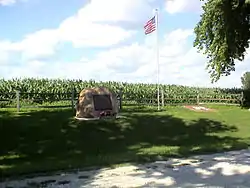 Memorial in Rushville | |
 Rushville Location within the state of Iowa  Rushville Rushville (the United States) | |
| Coordinates: 41°45′37″N 92°56′45″W / 41.76028°N 92.94583°W | |
| Country | United States |
| State | Iowa |
| County | Jasper |
| Elevation | 951 ft (290 m) |
| Time zone | UTC-6 (Central (CST)) |
| • Summer (DST) | UTC-5 (CDT) |
| ZIP codes | 50135 |
| Area code | 641 |
| GNIS feature ID | 464217 |
Rushville is a former unincorporated community in Kellogg Township, Jasper County, Iowa, United States.[1]
History
Rushville was platted in 1857[2] and it had its beginnings as a stage coach shop. The only store to ever exist in the town was operated by the Whitcomb family and contained the post office. Rushville had a church, several homes, and later a school.
Eventually, the railroad was constructed and bypassed Rushville to the south by two miles. This gradually led to the decline of the town. Rushville's population in 1915 was 1.[3]
In 1957, the school was consolidated into nearby Kellogg and the building was later demolished.
There are no longer any buildings in Rushville. Only a few nearby farms exist. A memorial plot containing a plaque, flag, and water pump remains within the city limits. Nearby Rushville Cemetery continues to be maintained.
References
- ↑ U.S. Geological Survey Geographic Names Information System: Rushville, Iowa
- ↑ Weaver, James Baird (1912). Past and Present of Jasper County, Iowa, Volume 1. B.F. Bowen. p. 361.
- ↑ Atlas of Johnson County, Iowa, 1917 :: Iowa Counties Historic Atlases. pp. 63–66.
Municipalities and communities of Jasper County, Iowa, United States | ||
|---|---|---|
| Cities | Map of Iowa highlighting Jasper County | |
| Townships | ||
| Unincorporated communities | ||
| Footnotes | ‡This populated place also has portions in an adjacent county or counties | |