Saint-Champ | |
|---|---|
Part of Magnieu | |
Location of Saint-Champ | |
 Saint-Champ  Saint-Champ | |
| Coordinates: 45°47′00″N 5°44′00″E / 45.7833°N 5.7333°E | |
| Country | France |
| Region | Auvergne-Rhône-Alpes |
| Department | Ain |
| Arrondissement | Belley |
| Canton | Belley |
| Commune | Magnieu |
| Area 1 | 5.14 km2 (1.98 sq mi) |
| Population (2018)[1] | 147 |
| • Density | 29/km2 (74/sq mi) |
| Time zone | UTC+01:00 (CET) |
| • Summer (DST) | UTC+02:00 (CEST) |
| Postal code | 01300 |
| Elevation | 286–554 m (938–1,818 ft) (avg. 351 m or 1,152 ft) |
| 1 French Land Register data, which excludes lakes, ponds, glaciers > 1 km2 (0.386 sq mi or 247 acres) and river estuaries. | |
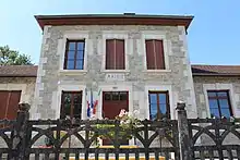
Mairie St Champ Chatonod
Saint-Champ (French pronunciation: [sɛ̃ ʃɑ̃]) is a former commune in the Ain department in eastern France. On 1 January 2019, it was merged into the commune of Magnieu.[2]
Population
| Year | Pop. | ±% p.a. |
|---|---|---|
| 2006 | 137 | — |
| 2011 | 144 | +1.00% |
| 2015 | 162 | +2.99% |
| 2018 | 147 | −3.19% |
| Source: INSEE[3][4][1] | ||
See also
References
- 1 2 Téléchargement du fichier d'ensemble des populations légales en 2018, INSEE
- ↑ Arrêté préfectoral 23 November 2018 (in French)
- ↑ Populations légales 2011, INSEE
- ↑ Populations légales 2015, INSEE
Wikimedia Commons has media related to Saint-Champ.
This article is issued from Wikipedia. The text is licensed under Creative Commons - Attribution - Sharealike. Additional terms may apply for the media files.