Saint-Didier-sous-Riverie | |
|---|---|
Part of Chabanière | |
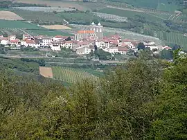 The village of Saint-Didier-sous-Riverie in the middle of orchards. | |
Location of Saint-Didier-sous-Riverie | |
 Saint-Didier-sous-Riverie  Saint-Didier-sous-Riverie | |
| Coordinates: 45°35′51″N 4°36′33″E / 45.5975°N 4.6092°E | |
| Country | France |
| Region | Auvergne-Rhône-Alpes |
| Department | Rhône |
| Arrondissement | Villefranche-sur-Saône |
| Canton | Mornant |
| Commune | Chabanière |
| Area 1 | 13.9 km2 (5.4 sq mi) |
| Population (2019)[1] | 1,287 |
| • Density | 93/km2 (240/sq mi) |
| Time zone | UTC+01:00 (CET) |
| • Summer (DST) | UTC+02:00 (CEST) |
| Postal code | 69440 |
| Elevation | 340–750 m (1,120–2,460 ft) (avg. 521 m or 1,709 ft) |
| 1 French Land Register data, which excludes lakes, ponds, glaciers > 1 km2 (0.386 sq mi or 247 acres) and river estuaries. | |
Saint-Didier-sous-Riverie (French pronunciation: [sɛ̃ didje su ʁivʁi], literally Saint-Didier under Riverie; Arpitan: Sant-Dediér) is a former commune in the Rhône department in eastern France. On 1 January 2017, it was merged into the new commune Chabanière.[2]
See also
References
- ↑ Téléchargement du fichier d'ensemble des populations légales en 2019, INSEE
- ↑ Arrêté préfectoral 5 October 2016 (in French)
Wikimedia Commons has media related to Saint-Didier-sous-Riverie.
This article is issued from Wikipedia. The text is licensed under Creative Commons - Attribution - Sharealike. Additional terms may apply for the media files.