Samern | |
|---|---|
Location of Samern within Grafschaft Bentheim district 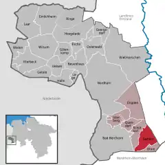 | |
 Samern 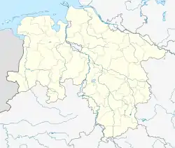 Samern | |
| Coordinates: 52°19′00″N 07°15′00″E / 52.31667°N 7.25000°E | |
| Country | Germany |
| State | Lower Saxony |
| District | Grafschaft Bentheim |
| Municipal assoc. | Schüttorf |
| Government | |
| • Mayor | Gerhard Schepers |
| Area | |
| • Total | 25.99 km2 (10.03 sq mi) |
| Elevation | 36 m (118 ft) |
| Population (2021-12-31)[1] | |
| • Total | 799 |
| • Density | 31/km2 (80/sq mi) |
| Time zone | UTC+01:00 (CET) |
| • Summer (DST) | UTC+02:00 (CEST) |
| Postal codes | 48465 |
| Dialling codes | 0 59 23 |
| Vehicle registration | NOH |
Samern is a community in the district of Grafschaft Bentheim in Lower Saxony, Germany.
Geography
Location
Samern lies between Nordhorn and Steinfurt on the boundary with North Rhine-Westphalia. The community belongs to the Joint Community (Samtgemeinde) of Schüttorf whose administrative seat is in the like-named town.
Politics
Mayor
The community’s honorary mayor is Gerhard Schepers.
Culture and sightseeing
The Mansbrügge watchtower, or in the local speech the Piggetörnken, was once, according to local lore, a mint belonging to a count in the 14th century. Newer findings, however, show that this building was only ever used as a customs post.
Sport
Samern has a sport club, SV Suddendorf-Samern 1959 e.V.
Economy and infrastructure
Transport
The Autobahn A 31 runs directly through the community of Samern.
References
External links
This article is issued from Wikipedia. The text is licensed under Creative Commons - Attribution - Sharealike. Additional terms may apply for the media files.