Sanam Chai Khet
สนามชัยเขต | |
|---|---|
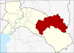 District location in Chachoengsao province | |
| Coordinates: 13°39′30″N 101°26′20″E / 13.65833°N 101.43889°E | |
| Country | Thailand |
| Province | Chachoengsao |
| Seat | Khu Yai Mi |
| Area | |
| • Total | 1,666.0 km2 (643.2 sq mi) |
| Population (2017) | |
| • Total | 74,613 |
| • Density | 44.78/km2 (116.0/sq mi) |
| Time zone | UTC+7 (ICT) |
| Postal code | 24160 |
| Geocode | 2408 |
Sanam Chai Khet (Thai: สนามชัยเขต, pronounced [sā.nǎːm t͡ɕʰāj kʰèːt]) is a district (amphoe) in the eastern part of Chachoengsao province, central Thailand.
History
Mueang Sanam Chai Khet was a city of the Ayutthaya Kingdom, a contemporary of neighboring Mueang Phanat Nikhom and Phanom Sarakham.
Being part of Phanom Sarakham district, on 6 January 1966 the three tambons, Khu Yai Mi, Tha Kradan, and Tha Takiap, were split off to form the minor district (king amphoe) Sanam Chai (สนามไชย).[1] It was renamed Sanam Chai Ket on 14 December 1972,[2] and upgraded to a full district on 28 June 1973.[3]
Geography
Neighboring districts are (from the west clockwise): Plaeng Yao and Phanom Sarakham of Chachoengsao Province; Si Maha Phot and Kabin Buri of Prachinburi province; Khao Chakan of Sa Kaeo province; Tha Takiap of Chachoengsao Province; and Ko Chan of Chonburi province.
Administration
Central administration
Sanam Chai Khet is divided into four sub-districts (tambons), which are further subdivided into 70 administrative villages (mubans).
| No. | Name | Thai | Villages | Pop.[4] |
|---|---|---|---|---|
| 1. | Khu Yai Mi | คู้ยายหมี | 17 | 16,459 |
| 2. | Tha Kradan | ท่ากระดาน | 23 | 30,861 |
| 3. | Thung Phraya | ทุ่งพระยา | 19 | 16,516 |
| 5. | Lat Krathing | ลาดกระทิง | 11 | 10,777 |
Missing numbers are tambon which now form Tha Takiap.
Local administration
There is one sub-district municipality (thesaban tambon) in the district, Sanam Chai Khet (Thai: เทศบาลตำบลสนามชัยเขต) consisting of parts of sub-district Khu Yai Mi.
There are four sub-district administrative organizations (SAO) in the district:
- Khu Yai Mi (Thai: องค์การบริหารส่วนตำบลคู้ยายหมี) consisting of parts of sub-district Khu Yai Mi.
- Tha Kradan (Thai: องค์การบริหารส่วนตำบลท่ากระดาน) consisting of sub-district Tha Kradan.
- Thung Phraya (Thai: องค์การบริหารส่วนตำบลทุ่งพระยา) consisting of sub-district Thung Phraya.
- Lat Krathing (Thai: องค์การบริหารส่วนตำบลลาดกระทิง) consisting of sub-district Lat Krathing.
References
- ↑ ประกาศกระทรวงมหาดไทย เรื่อง แบ่งท้องที่ตั้งเป็นกิ่งอำเภอ (PDF). Royal Gazette (in Thai). 83 (6 ง): 254. January 18, 1966. Archived from the original (PDF) on May 4, 2012.
- ↑ ประกาศกระทรวงมหาดไทย เรื่อง เปลี่ยนชื่อกิ่งอำเภอ และตำบลบางแห่ง (PDF). Royal Gazette (in Thai). 89 (195 ง): 3015. December 19, 1972. Archived from the original (PDF) on May 4, 2012.
- ↑ พระราชกฤษฎีกาตั้งอำเภอเขาพนม อำเภอสนามชัยเขต อำเภอแม่อาย อำเภอขามสะแกแสง อำเภอเก้าเลี้ยว อำเภอโพธิ์ประทับช้าง อำเภอหนองพอก อำเภอละอุ่น อำเภอทุ่งหว้า และอำเภอศรีธาตุ พ.ศ. ๒๕๑๖ (PDF). Royal Gazette (in Thai). 90 (75 ก special): 32–36. June 28, 1973. Archived from the original (PDF) on February 24, 2012.
- ↑ "Population statistics 2017" (in Thai). Department of Provincial Administration. Retrieved 2018-04-04.
External links