Sanguem | |
|---|---|
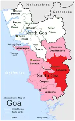 Location of Sanguem in South Goa district in Goa | |
| Coordinates: 15°13′42″N 74°09′08″E / 15.228420°N 74.152152°E | |
| Country | |
| State | Goa |
| District | South Goa district |
| Headquarters | Sanguem city |
| Settlements (as of 2011) | 1 City 1 Town 45 Villages |
| Government | |
| • Tehsildar | Ajay Gaude |
| • Lok Sabha constituency | North Goa |
| • Assembly constituency | Sanguem (Goa Assembly constituency) |
| • MLA | Prasad Gaonkar |
| Population (2011) | |
| • Taluka | 65,147 |
| • Urban | 17.72% |
| Demographics | |
| • Literacy rate | na |
| • Sex ratio | na |
| PIN | 4034XX, 4037XX |
| Vehicle registration | GA-09 |
| Rain | na |
Sanguem taluka is an administrative region of Goa state, India.[1][2]
Settlements
Many of the Villages mentioned below were ceded to the Dharbandora Sub-Division.
Cities
Sanguem has 1 City: Sanguem City
Towns
Sanguem has 1 Town: Sanvordem
Villages
Sanguem has 45 Villages: Aglote, Bandoli, Bati, Calem, Camarconda, Caranzol, Codli, Colem, Colomba, Comproi, Coranginim, Cormonem, Costi, Cotarli, Cumbari, Curdi, Curpem, Dharbandora, Dongor, Dudal, Maulinguem, Moissal, Molem, Muguli, Naiquinim, Netorli, Nundem, Patiem, Piliem, Porteem, Potrem, Rivona, Rumbrem, Sancordem, Sangod, Santona, Sigao, Sonauli, Surla, Tudou, Uguem, Verlem, Vichundrem, Viliena, Xelpem
Places adjacent to Sanguem taluka | ||||||||||||||||
|---|---|---|---|---|---|---|---|---|---|---|---|---|---|---|---|---|
| ||||||||||||||||
References
- ↑ "Village Maps of India". villagemap.in. Retrieved 12 February 2013.
- ↑ "Sanguem S.O Post Office – SANGUEM, SOUTH GOA, Goa". IndiaOnline Pincodes. Retrieved 12 February 2013.
External links
http://www.census2011.co.in/data/subdistrict/5618-sanguem-south-goa-goa.html
| History | |||||||
|---|---|---|---|---|---|---|---|
| Government | |||||||
| Geography |
| ||||||
| Districts | |||||||
| Talukas | |||||||
| Cities | |||||||
| Heritage sites | |||||||
| Wildlife sanctuaries | |||||||
| Education |
| ||||||
| Science | |||||||
| Culture | |||||||
| Sports |
| ||||||
| Transport | |||||||
| |||||||
This article is issued from Wikipedia. The text is licensed under Creative Commons - Attribution - Sharealike. Additional terms may apply for the media files.