Sankt Bartholomä | |
|---|---|
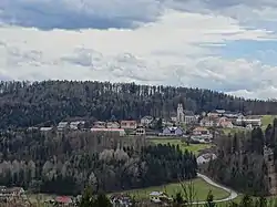 View of Sankt Bartholomä | |
 Coat of arms | |
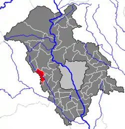 Location within Graz-Umgebung district | |
 Sankt Bartholomä Location within Austria | |
| Coordinates: 47°04′08″N 15°15′26″E / 47.06889°N 15.25722°E | |
| Country | Austria |
| State | Styria |
| District | Graz-Umgebung |
| Government | |
| • Mayor | Josef Birnstingl (ÖVP) |
| Area | |
| • Total | 11.75 km2 (4.54 sq mi) |
| Elevation | 499 m (1,637 ft) |
| Population (2018-01-01)[2] | |
| • Total | 1,442 |
| • Density | 120/km2 (320/sq mi) |
| Time zone | UTC+1 (CET) |
| • Summer (DST) | UTC+2 (CEST) |
| Postal code | 8113, 8151 |
| Area code | 03123 |
| Vehicle registration | GU |
| Website | www.st-bartholomae.gv.at |
Sankt Bartholomä is a municipality in the district of Graz-Umgebung in the Austrian state of Styria.
Population
| Year | Pop. | ±% |
|---|---|---|
| 1869 | 1,032 | — |
| 1880 | 1,078 | +4.5% |
| 1890 | 1,063 | −1.4% |
| 1900 | 1,057 | −0.6% |
| 1910 | 1,107 | +4.7% |
| 1923 | 1,017 | −8.1% |
| 1934 | 990 | −2.7% |
| 1939 | 980 | −1.0% |
| 1951 | 1,043 | +6.4% |
| 1961 | 1,073 | +2.9% |
| 1971 | 1,159 | +8.0% |
| 1981 | 1,220 | +5.3% |
| 1991 | 1,361 | +11.6% |
| 2001 | 1,399 | +2.8% |
References
- ↑ "Dauersiedlungsraum der Gemeinden Politischen Bezirke und Bundesländer - Gebietsstand 1.1.2018". Statistics Austria. Retrieved 10 March 2019.
- ↑ "Einwohnerzahl 1.1.2018 nach Gemeinden mit Status, Gebietsstand 1.1.2018". Statistics Austria. Retrieved 9 March 2019.
This article is issued from Wikipedia. The text is licensed under Creative Commons - Attribution - Sharealike. Additional terms may apply for the media files.