Saraféré | |
|---|---|
Village | |
 Saraféré Location in Mali | |
| Coordinates: 15°49′22″N 3°41′55″W / 15.82278°N 3.69861°W | |
| Country | |
| Region | Tombouctou Region |
| Cercle | Niafunke Cercle |
| Commune | Fittouga |
| Time zone | UTC+0 (GMT) |
Saraféré is a village and seat of the commune of Fittouga in the Cercle of Niafunke in the Tombouctou Region of Mali.[1] The village lies on the Barra-Issa, the smaller and more easterly branch of the Niger River in the Inner Niger Delta.
Visit by Edmond Fortier
The French photographer, Edmond Fortier, visited the village in 1905-1906 and published a series of postcards.
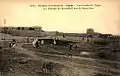 View of the village
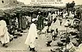 Street market
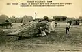 Building a pirogue
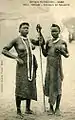 Two women
References
Wikimedia Commons has media related to Saraféré.
- ↑ Schéma Directeur de Lutte Contre l’Ensablement dans le Nord du Mali (6ème et 7ème Régions): Monographie de la Commune de Fitouga (PDF) (in French), Ministère de l’Environnement et de l’Assainissement, République du Mali, 2004, archived from the original (PDF) on 2011-07-22
Capital: Timbuktu | ||
| Diré Cercle | 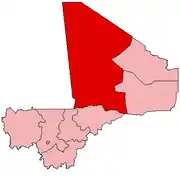 | |
| Goundam Cercle |
| |
| Gourma-Rharous Cercle | ||
| Niafunké Cercle | ||
| Timbuktu Cercle |
| |
This article is issued from Wikipedia. The text is licensed under Creative Commons - Attribution - Sharealike. Additional terms may apply for the media files.