Highway 904 | ||||
|---|---|---|---|---|
| Route information | ||||
| Maintained by Ministry of Highways and Infrastructure | ||||
| Length | 47 km[1] (29 mi) | |||
| History | Formerly Hwy 104 | |||
| Major junctions | ||||
| South end | ||||
| North end | Meadow Lake Provincial Park northern boundary | |||
| Location | ||||
| Country | Canada | |||
| Province | Saskatchewan | |||
| Rural municipalities | Meadow Lake No. 588 | |||
| Highway system | ||||
|
| ||||
| ||||
.svg.png.webp)
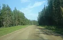
Hwy 904 in the Meadow Lake Provincial Park.
Highway 904 is a provincial highway in the north-west region of the Canadian province of Saskatchewan. It travels from the Highway 4 / Highway 224 in the Meadow Lake Provincial Park to north boundary of park at the edge of the Cold Lake Air Weapons Range.[2] It intersects Highway 951 within the park. It is about 47 kilometres (29 mi) long.[1]
Highway 904 was once Highway 104, a northerly extension of Highway 4; it was replaced in the early 1980s.[3][4]
See also
References
- 1 2 Google (21 February 2018). "Highway 904 in Saskatchewan" (Map). Google Maps. Google. Retrieved 21 February 2018.
- ↑ Government of Saskatchewan (2016). Saskatchewan Official Road Map (Map) (2016/2017 ed.). Tourism Saskatchewan. § B-6.
- ↑ Saskatchewan Department of Highways and Transportation (1980). Official Highway Map (Map). Queen's Printer. § B-6.
- ↑ Saskatchewan Department of Highways and Transportation (1984). Official Highway Map (Map). Queen's Printer. § B-6.
This article is issued from Wikipedia. The text is licensed under Creative Commons - Attribution - Sharealike. Additional terms may apply for the media files.