Schwendt | |
|---|---|
 | |
 Coat of arms | |
 Schwendt Location within Austria | |
| Coordinates: 47°38′00″N 12°24′00″E / 47.63333°N 12.40000°E | |
| Country | Austria |
| State | Tyrol |
| District | Kitzbühel |
| Government | |
| • Mayor | Sebastian Haunholter |
| Area | |
| • Total | 30.85 km2 (11.91 sq mi) |
| Elevation | 702 m (2,303 ft) |
| Population (2018-01-01)[2] | |
| • Total | 823 |
| • Density | 27/km2 (69/sq mi) |
| Time zone | UTC+1 (CET) |
| • Summer (DST) | UTC+2 (CEST) |
| Postal code | 6385 |
| Area code | 05375 |
| Vehicle registration | KB |
| Website | www.riskommunal.net/ schwendt |
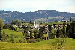
Schwendt is a municipality in the Kitzbühel district in the Austrian state of Tyrol located 17 km north of Kitzbühel and 6 km below Kössen.
The name of the village comes from the old word "schwenden" (meaning to grub-up).
Agriculture and tourism are its main sources of income.
Population
|
|
References
- ↑ "Dauersiedlungsraum der Gemeinden Politischen Bezirke und Bundesländer - Gebietsstand 1.1.2018". Statistics Austria. Retrieved 10 March 2019.
- ↑ "Einwohnerzahl 1.1.2018 nach Gemeinden mit Status, Gebietsstand 1.1.2018". Statistics Austria. Retrieved 9 March 2019.
Wikimedia Commons has media related to Schwendt.
This article is issued from Wikipedia. The text is licensed under Creative Commons - Attribution - Sharealike. Additional terms may apply for the media files.