Seregélyes | |
|---|---|
Large village | |
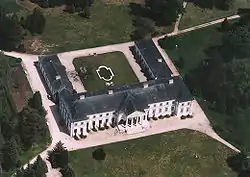 Aerial photography of Zichy palace | |
 Flag  Coat of arms | |
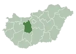
 Seregélyes Location of Seregélyes | |
| Coordinates: 47°06′39″N 18°34′38″E / 47.11092°N 18.57731°E | |
| Country | |
| County | Fejér |
| District | Székesfehérvár |
| Area | |
| • Total | 78.19 km2 (30.19 sq mi) |
| Population (2004) | |
| • Total | 4,716 |
| • Density | 60.31/km2 (156.2/sq mi) |
| Time zone | UTC+1 (CET) |
| • Summer (DST) | UTC+2 (CEST) |
| Postal code | 8111 |
| Area code | (+36) 22 |
Education
Localities
- Ambrustanya, a former village
External links
![]() Media related to Seregélyes at Wikimedia Commons
Media related to Seregélyes at Wikimedia Commons
- Official website in Hungarian
- Street map (in Hungarian)
| City with county rights |
| |
|---|---|---|
| Towns | ||
| Large villages | ||
| Villages | ||
| Cities with county rights |
|   |
|---|---|---|
| Towns | ||
| Large villages | ||
| Villages |
| |
| Other topics |
| |
This article is issued from Wikipedia. The text is licensed under Creative Commons - Attribution - Sharealike. Additional terms may apply for the media files.